You are here: Home > Network List > TA - USArray Transportable Network (new EarthScope stations) Stations List
> Station I17K Unalakleet, AK, USA > Earthquake Result Viewer
I17K Unalakleet, AK, USA - Earthquake Result Viewer
| Earthquake location: |
Near West Coast Of Honshu, Japan |
| Earthquake latitude/longitude: |
38.6/139.5 |
| Earthquake time(UTC): |
2019/06/18 (169) 13:22:19 GMT |
| Earthquake Depth: |
12 km |
| Earthquake Magnitude: |
6.4 Mww |
| Earthquake Catalog/Contributor: |
NEIC PDE/us |
|
| Network: |
TA USArray Transportable Network (new EarthScope stations) |
| Station: |
I17K Unalakleet, AK, USA |
| Lat/Lon: |
63.89 N/160.70 W |
| Elevation: |
105 m |
|
| Distance: |
43.0 deg |
| Az: |
34.157 deg |
| Baz: |
263.458 deg |
| Ray Param: |
0.07285453 |
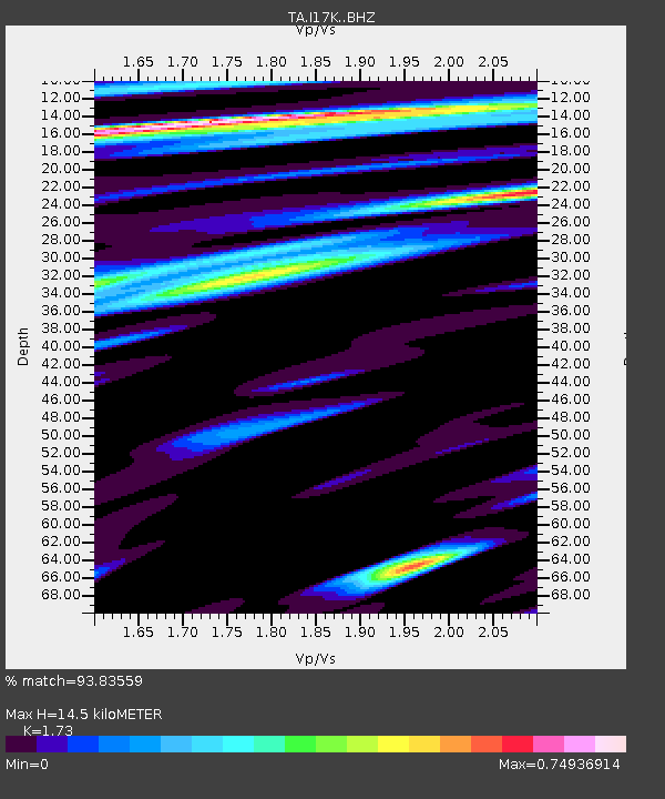
| Estimated Moho Depth: |
14.5 km |
| Estimated Crust Vp/Vs: |
1.73 |
| Assumed Crust Vp: |
6.276 km/s |
| Estimated Crust Vs: |
3.628 km/s |
| Estimated Crust Poisson's Ratio: |
0.25 |
|
| Radial Match: |
93.83559 % |
| Radial Bump: |
400 |
| Transverse Match: |
85.84477 % |
| Transverse Bump: |
400 |
| SOD ConfigId: |
18369291 |
| Insert Time: |
2019-07-02 13:33:23.594 +0000 |
| GWidth: |
2.5 |
| Max Bumps: |
400 |
| Tol: |
0.001 |
|
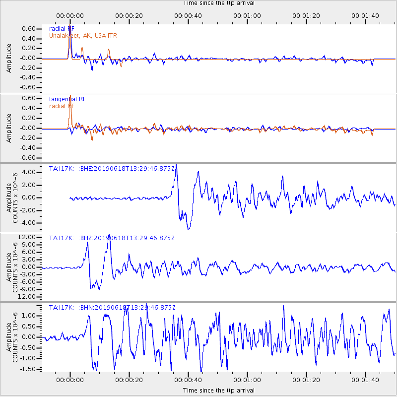
Signal To Noise
| Channel | StoN | STA | LTA |
| TA:I17K: :BHZ:20190618T13:29:46.875Z | 11.925644 | 1.092369E-6 | 9.1598324E-8 |
| TA:I17K: :BHN:20190618T13:29:46.875Z | 1.0858458 | 8.867443E-8 | 8.166392E-8 |
| TA:I17K: :BHE:20190618T13:29:46.875Z | 4.6722784 | 5.171248E-7 | 1.1067937E-7 |
| Arrivals |
| Ps | 1.8 SECOND |
| PpPs | 5.9 SECOND |
| PsPs/PpSs | 7.7 SECOND |


