You are here: Home > Network List > TA - USArray Transportable Network (new EarthScope stations) Stations List
> Station J26L Joseph Creek, AK, USA > Earthquake Result Viewer
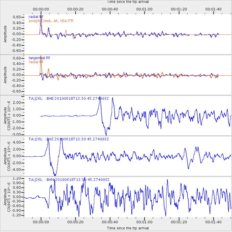
J26L Joseph Creek, AK, USA - Earthquake Result Viewer
| Earthquake location: |
Near West Coast Of Honshu, Japan |
| Earthquake latitude/longitude: |
38.6/139.5 |
| Earthquake time(UTC): |
2019/06/18 (169) 13:22:19 GMT |
| Earthquake Depth: |
12 km |
| Earthquake Magnitude: |
6.4 Mww |
| Earthquake Catalog/Contributor: |
NEIC PDE/us |
|
| Network: |
TA USArray Transportable Network (new EarthScope stations) |
| Station: |
J26L Joseph Creek, AK, USA |
| Lat/Lon: |
64.50 N/143.56 W |
| Elevation: |
1144 m |
|
| Distance: |
50.4 deg |
| Az: |
33.169 deg |
| Baz: |
278.204 deg |
| Ray Param: |
0.068062566 |
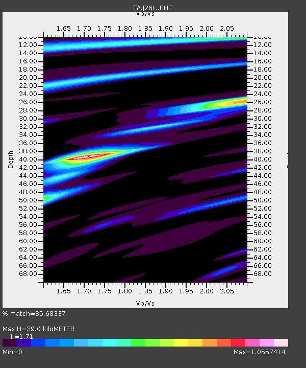
| Estimated Moho Depth: |
39.0 km |
| Estimated Crust Vp/Vs: |
1.71 |
| Assumed Crust Vp: |
6.566 km/s |
| Estimated Crust Vs: |
3.84 km/s |
| Estimated Crust Poisson's Ratio: |
0.24 |
|
| Radial Match: |
85.68337 % |
| Radial Bump: |
400 |
| Transverse Match: |
77.55639 % |
| Transverse Bump: |
400 |
| SOD ConfigId: |
18369291 |
| Insert Time: |
2019-07-02 13:33:32.324 +0000 |
| GWidth: |
2.5 |
| Max Bumps: |
400 |
| Tol: |
0.001 |
|
Signal To Noise
| Channel | StoN | STA | LTA |
| TA:J26L: :BHZ:20190618T13:30:45.274993Z | 42.153217 | 2.0906184E-6 | 4.95957E-8 |
| TA:J26L: :BHN:20190618T13:30:45.274993Z | 7.4774523 | 2.6173856E-7 | 3.500371E-8 |
| TA:J26L: :BHE:20190618T13:30:45.274993Z | 31.220078 | 1.2086971E-6 | 3.8715378E-8 |
| Arrivals |
| Ps | 4.5 SECOND |
| PpPs | 15 SECOND |
| PsPs/PpSs | 20 SECOND |


