You are here: Home > Network List > TA - USArray Transportable Network (new EarthScope stations) Stations List
> Station C17A Wharram Farm, Highwood, MT, USA > Earthquake Result Viewer
C17A Wharram Farm, Highwood, MT, USA - Earthquake Result Viewer

| Earthquake location: |
Chile-Argentina Border Region |
| Earthquake latitude/longitude: |
-24.8/-68.5 |
| Earthquake time(UTC): |
2007/11/21 (325) 12:55:05 GMT |
| Earthquake Depth: |
115 km |
| Earthquake Magnitude: |
5.6 MB, 5.8 MW, 5.8 MW |
| Earthquake Catalog/Contributor: |
WHDF/NEIC |
|
| Network: |
TA USArray Transportable Network (new EarthScope stations) |
| Station: |
C17A Wharram Farm, Highwood, MT, USA |
| Lat/Lon: |
47.63 N/110.76 W |
| Elevation: |
1080 m |
|
| Distance: |
81.5 deg |
| Az: |
332.605 deg |
| Baz: |
141.812 deg |
| Ray Param: |
0.047259416 |
| Estimated Moho Depth: |
36.0 km |
| Estimated Crust Vp/Vs: |
1.69 |
| Assumed Crust Vp: |
6.306 km/s |
| Estimated Crust Vs: |
3.731 km/s |
| Estimated Crust Poisson's Ratio: |
0.23 |
|
| Radial Match: |
82.24215 % |
| Radial Bump: |
400 |
| Transverse Match: |
61.791973 % |
| Transverse Bump: |
344 |
| SOD ConfigId: |
2564 |
| Insert Time: |
2010-03-07 00:06:31.706 +0000 |
| GWidth: |
2.5 |
| Max Bumps: |
400 |
| Tol: |
0.001 |
|
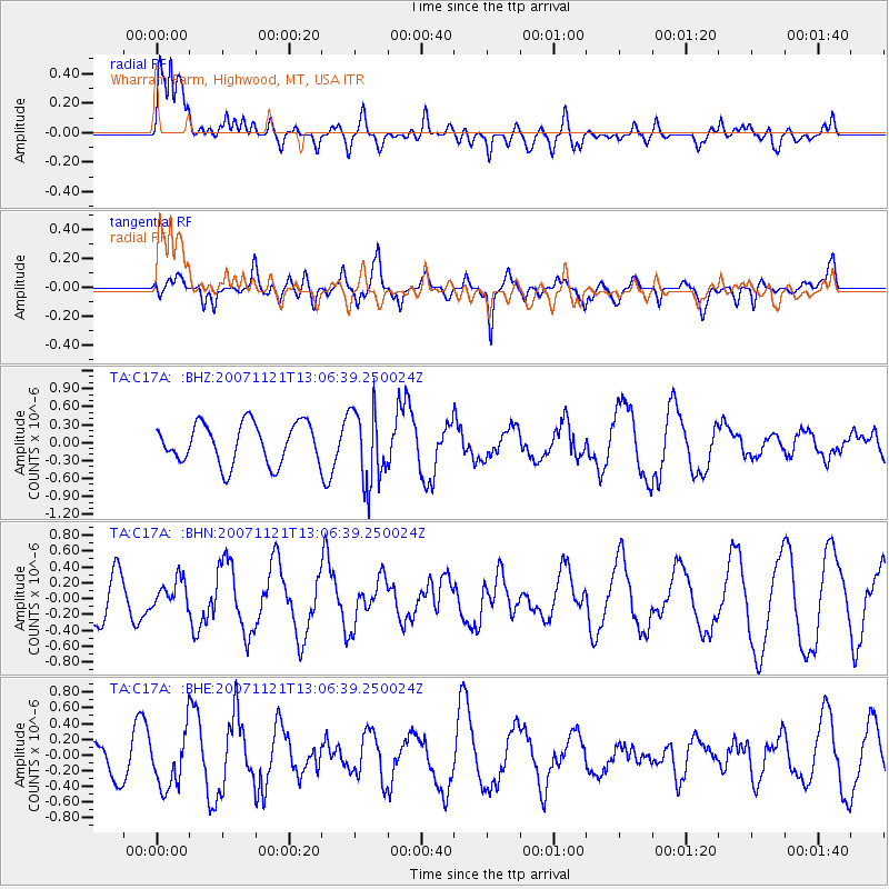
Signal To Noise
| Channel | StoN | STA | LTA |
| TA:C17A: :BHN:20071121T13:06:39.250024Z | 0.73900455 | 1.7465345E-7 | 2.3633609E-7 |
| TA:C17A: :BHE:20071121T13:06:39.250024Z | 1.8869288 | 3.5321008E-7 | 1.8718781E-7 |
| TA:C17A: :BHZ:20071121T13:06:39.250024Z | 1.845616 | 6.1834686E-7 | 3.350355E-7 |
| Arrivals |
| Ps | 4.0 SECOND |
| PpPs | 15 SECOND |
| PsPs/PpSs | 19 SECOND |


