You are here: Home > Network List > TA - USArray Transportable Network (new EarthScope stations) Stations List
> Station L19K White Mountain, AK, USA > Earthquake Result Viewer
L19K White Mountain, AK, USA - Earthquake Result Viewer
| Earthquake location: |
Near West Coast Of Honshu, Japan |
| Earthquake latitude/longitude: |
38.6/139.5 |
| Earthquake time(UTC): |
2019/06/18 (169) 13:22:19 GMT |
| Earthquake Depth: |
12 km |
| Earthquake Magnitude: |
6.4 Mww |
| Earthquake Catalog/Contributor: |
NEIC PDE/us |
|
| Network: |
TA USArray Transportable Network (new EarthScope stations) |
| Station: |
L19K White Mountain, AK, USA |
| Lat/Lon: |
62.18 N/154.85 W |
| Elevation: |
650 m |
|
| Distance: |
45.5 deg |
| Az: |
36.803 deg |
| Baz: |
270.554 deg |
| Ray Param: |
0.07121473 |
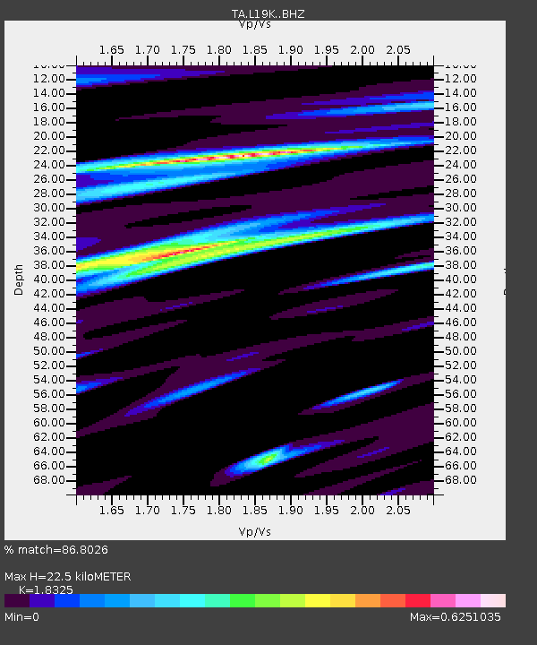
| Estimated Moho Depth: |
22.5 km |
| Estimated Crust Vp/Vs: |
1.83 |
| Assumed Crust Vp: |
6.438 km/s |
| Estimated Crust Vs: |
3.513 km/s |
| Estimated Crust Poisson's Ratio: |
0.29 |
|
| Radial Match: |
86.8026 % |
| Radial Bump: |
400 |
| Transverse Match: |
80.23402 % |
| Transverse Bump: |
400 |
| SOD ConfigId: |
18369291 |
| Insert Time: |
2019-07-02 13:33:40.225 +0000 |
| GWidth: |
2.5 |
| Max Bumps: |
400 |
| Tol: |
0.001 |
|

Signal To Noise
| Channel | StoN | STA | LTA |
| TA:L19K: :BHZ:20190618T13:30:07.424987Z | 18.07232 | 9.998851E-7 | 5.532688E-8 |
| TA:L19K: :BHN:20190618T13:30:07.424987Z | 0.75049007 | 5.1836878E-8 | 6.907071E-8 |
| TA:L19K: :BHE:20190618T13:30:07.424987Z | 11.199732 | 4.738583E-7 | 4.2309793E-8 |
| Arrivals |
| Ps | 3.1 SECOND |
| PpPs | 9.3 SECOND |
| PsPs/PpSs | 12 SECOND |


