You are here: Home > Network List > UU - University of Utah Regional Network Stations List
> Station RDMU Red Mountain, UT, USA > Earthquake Result Viewer
RDMU Red Mountain, UT, USA - Earthquake Result Viewer
| Earthquake location: |
Near East Coast Of Honshu, Japan |
| Earthquake latitude/longitude: |
37.4/141.4 |
| Earthquake time(UTC): |
2016/11/21 (326) 20:59:49 GMT |
| Earthquake Depth: |
11 km |
| Earthquake Magnitude: |
6.9 MWB, 7.3 MI |
| Earthquake Catalog/Contributor: |
NEIC PDE/NEIC COMCAT |
|
| Network: |
UU University of Utah Regional Network |
| Station: |
RDMU Red Mountain, UT, USA |
| Lat/Lon: |
40.57 N/109.57 W |
| Elevation: |
2087 m |
|
| Distance: |
78.8 deg |
| Az: |
47.229 deg |
| Baz: |
309.868 deg |
| Ray Param: |
0.0493821 |
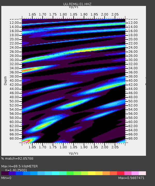
| Estimated Moho Depth: |
69.5 km |
| Estimated Crust Vp/Vs: |
1.61 |
| Assumed Crust Vp: |
6.207 km/s |
| Estimated Crust Vs: |
3.849 km/s |
| Estimated Crust Poisson's Ratio: |
0.19 |
|
| Radial Match: |
92.85788 % |
| Radial Bump: |
400 |
| Transverse Match: |
83.89628 % |
| Transverse Bump: |
400 |
| SOD ConfigId: |
1858631 |
| Insert Time: |
2016-12-05 21:06:38.590 +0000 |
| GWidth: |
2.5 |
| Max Bumps: |
400 |
| Tol: |
0.001 |
|

Signal To Noise
| Channel | StoN | STA | LTA |
| UU:RDMU:01:HHZ:20161121T21:11:20.359976Z | 7.380838 | 4.7234856E-8 | 6.3996604E-9 |
| UU:RDMU:01:HHN:20161121T21:11:20.359976Z | 2.8033807 | 1.3021552E-8 | 4.6449458E-9 |
| UU:RDMU:01:HHE:20161121T21:11:20.359976Z | 1.7340003 | 9.354544E-9 | 5.394776E-9 |
| Arrivals |
| Ps | 7.1 SECOND |
| PpPs | 28 SECOND |
| PsPs/PpSs | 35 SECOND |


