You are here: Home > Network List > TA - USArray Transportable Network (new EarthScope stations) Stations List
> Station C17A Wharram Farm, Highwood, MT, USA > Earthquake Result Viewer
C17A Wharram Farm, Highwood, MT, USA - Earthquake Result Viewer
| Earthquake location: |
Northern Chile |
| Earthquake latitude/longitude: |
-22.2/-69.9 |
| Earthquake time(UTC): |
2007/11/14 (318) 15:40:50 GMT |
| Earthquake Depth: |
40 km |
| Earthquake Magnitude: |
6.7 MB, 7.4 MS, 7.7 MW, 7.4 ME |
| Earthquake Catalog/Contributor: |
WHDF/NEIC |
|
| Network: |
TA USArray Transportable Network (new EarthScope stations) |
| Station: |
C17A Wharram Farm, Highwood, MT, USA |
| Lat/Lon: |
47.63 N/110.76 W |
| Elevation: |
1080 m |
|
| Distance: |
78.7 deg |
| Az: |
333.167 deg |
| Baz: |
141.807 deg |
| Ray Param: |
0.04942444 |
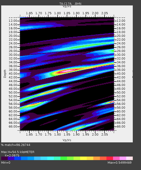
| Estimated Moho Depth: |
54.5 km |
| Estimated Crust Vp/Vs: |
2.10 |
| Assumed Crust Vp: |
6.306 km/s |
| Estimated Crust Vs: |
3.006 km/s |
| Estimated Crust Poisson's Ratio: |
0.35 |
|
| Radial Match: |
96.26744 % |
| Radial Bump: |
400 |
| Transverse Match: |
85.219 % |
| Transverse Bump: |
400 |
| SOD ConfigId: |
2564 |
| Insert Time: |
2010-03-07 00:06:40.538 +0000 |
| GWidth: |
2.5 |
| Max Bumps: |
400 |
| Tol: |
0.001 |
|

Signal To Noise
| Channel | StoN | STA | LTA |
| TA:C17A: :BHN:20071114T15:52:17.399019Z | 8.442717 | 1.5205338E-6 | 1.8010007E-7 |
| TA:C17A: :BHE:20071114T15:52:17.399019Z | 10.80383 | 1.2952333E-6 | 1.198865E-7 |
| TA:C17A: :BHZ:20071114T15:52:17.399019Z | 23.152512 | 4.7149765E-6 | 2.036486E-7 |
| Arrivals |
| Ps | 9.7 SECOND |
| PpPs | 26 SECOND |
| PsPs/PpSs | 36 SECOND |


