You are here: Home > Network List > TA - USArray Transportable Network (new EarthScope stations) Stations List
> Station C17A Wharram Farm, Highwood, MT, USA > Earthquake Result Viewer
C17A Wharram Farm, Highwood, MT, USA - Earthquake Result Viewer

| Earthquake location: |
East Of Kuril Islands |
| Earthquake latitude/longitude: |
46.0/154.2 |
| Earthquake time(UTC): |
2007/10/25 (298) 13:50:02 GMT |
| Earthquake Depth: |
10 km |
| Earthquake Magnitude: |
6.0 MB, 5.7 MS, 6.1 MW, 5.9 MW |
| Earthquake Catalog/Contributor: |
WHDF/NEIC |
|
| Network: |
TA USArray Transportable Network (new EarthScope stations) |
| Station: |
C17A Wharram Farm, Highwood, MT, USA |
| Lat/Lon: |
47.63 N/110.76 W |
| Elevation: |
1080 m |
|
| Distance: |
60.9 deg |
| Az: |
50.485 deg |
| Baz: |
307.35 deg |
| Ray Param: |
0.061258454 |
| Estimated Moho Depth: |
41.0 km |
| Estimated Crust Vp/Vs: |
1.69 |
| Assumed Crust Vp: |
6.306 km/s |
| Estimated Crust Vs: |
3.726 km/s |
| Estimated Crust Poisson's Ratio: |
0.23 |
|
| Radial Match: |
87.54084 % |
| Radial Bump: |
364 |
| Transverse Match: |
86.59255 % |
| Transverse Bump: |
400 |
| SOD ConfigId: |
2564 |
| Insert Time: |
2010-03-07 00:06:42.128 +0000 |
| GWidth: |
2.5 |
| Max Bumps: |
400 |
| Tol: |
0.001 |
|
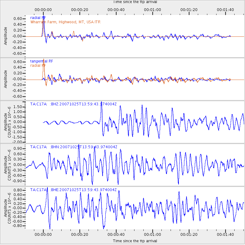
Signal To Noise
| Channel | StoN | STA | LTA |
| TA:C17A: :BHN:20071025T13:59:43.974004Z | 3.774297 | 3.7550205E-7 | 9.948927E-8 |
| TA:C17A: :BHE:20071025T13:59:43.974004Z | 4.5432067 | 4.566232E-7 | 1.0050681E-7 |
| TA:C17A: :BHZ:20071025T13:59:43.974004Z | 8.3234215 | 7.923741E-7 | 9.519812E-8 |
| Arrivals |
| Ps | 4.7 SECOND |
| PpPs | 17 SECOND |
| PsPs/PpSs | 21 SECOND |


