You are here: Home > Network List > TA - USArray Transportable Network (new EarthScope stations) Stations List
> Station M27K Edge Creek, AK, USA > Earthquake Result Viewer
M27K Edge Creek, AK, USA - Earthquake Result Viewer
| Earthquake location: |
Near West Coast Of Honshu, Japan |
| Earthquake latitude/longitude: |
38.6/139.5 |
| Earthquake time(UTC): |
2019/06/18 (169) 13:22:19 GMT |
| Earthquake Depth: |
12 km |
| Earthquake Magnitude: |
6.4 Mww |
| Earthquake Catalog/Contributor: |
NEIC PDE/us |
|
| Network: |
TA USArray Transportable Network (new EarthScope stations) |
| Station: |
M27K Edge Creek, AK, USA |
| Lat/Lon: |
62.36 N/141.88 W |
| Elevation: |
1536 m |
|
| Distance: |
51.5 deg |
| Az: |
35.733 deg |
| Baz: |
281.324 deg |
| Ray Param: |
0.067347 |
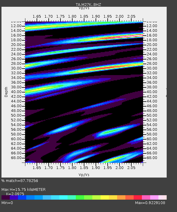
| Estimated Moho Depth: |
15.75 km |
| Estimated Crust Vp/Vs: |
2.10 |
| Assumed Crust Vp: |
6.566 km/s |
| Estimated Crust Vs: |
3.13 km/s |
| Estimated Crust Poisson's Ratio: |
0.35 |
|
| Radial Match: |
87.78256 % |
| Radial Bump: |
400 |
| Transverse Match: |
78.24553 % |
| Transverse Bump: |
400 |
| SOD ConfigId: |
18369291 |
| Insert Time: |
2019-07-02 13:33:50.680 +0000 |
| GWidth: |
2.5 |
| Max Bumps: |
400 |
| Tol: |
0.001 |
|

Signal To Noise
| Channel | StoN | STA | LTA |
| TA:M27K: :BHZ:20190618T13:30:53.625Z | 12.546368 | 9.837584E-7 | 7.840981E-8 |
| TA:M27K: :BHN:20190618T13:30:53.625Z | 2.0961268 | 1.2782972E-7 | 6.098377E-8 |
| TA:M27K: :BHE:20190618T13:30:53.625Z | 5.452929 | 4.3901463E-7 | 8.050988E-8 |
| Arrivals |
| Ps | 2.8 SECOND |
| PpPs | 7.1 SECOND |
| PsPs/PpSs | 9.8 SECOND |


