You are here: Home > Network List > TA - USArray Transportable Network (new EarthScope stations) Stations List
> Station S12K Black Hills, AK, USA > Earthquake Result Viewer
S12K Black Hills, AK, USA - Earthquake Result Viewer
| Earthquake location: |
Near West Coast Of Honshu, Japan |
| Earthquake latitude/longitude: |
38.6/139.5 |
| Earthquake time(UTC): |
2019/06/18 (169) 13:22:19 GMT |
| Earthquake Depth: |
12 km |
| Earthquake Magnitude: |
6.4 Mww |
| Earthquake Catalog/Contributor: |
NEIC PDE/us |
|
| Network: |
TA USArray Transportable Network (new EarthScope stations) |
| Station: |
S12K Black Hills, AK, USA |
| Lat/Lon: |
55.70 N/162.06 W |
| Elevation: |
411 m |
|
| Distance: |
41.9 deg |
| Az: |
46.28 deg |
| Baz: |
271.241 deg |
| Ray Param: |
0.07350513 |
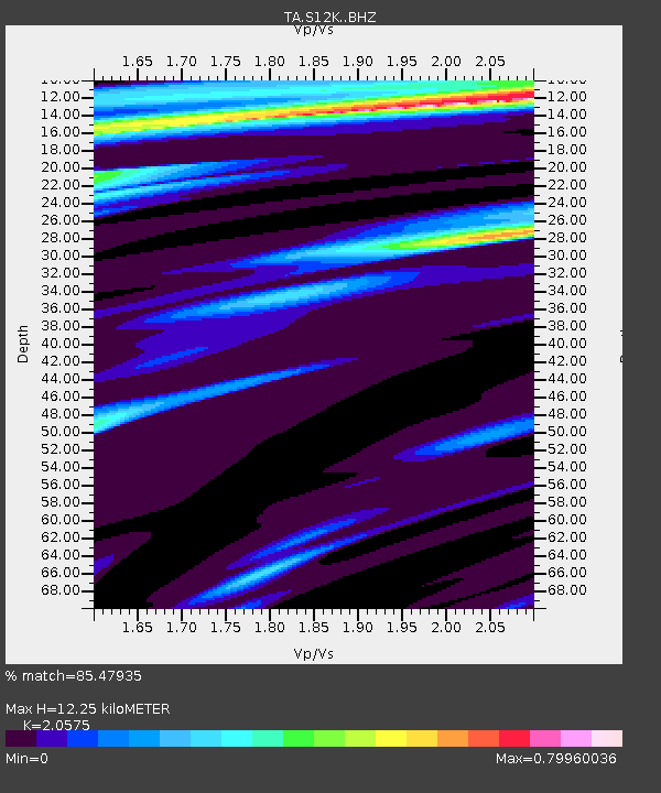
| Estimated Moho Depth: |
12.25 km |
| Estimated Crust Vp/Vs: |
2.06 |
| Assumed Crust Vp: |
5.989 km/s |
| Estimated Crust Vs: |
2.911 km/s |
| Estimated Crust Poisson's Ratio: |
0.35 |
|
| Radial Match: |
85.47935 % |
| Radial Bump: |
333 |
| Transverse Match: |
33.951668 % |
| Transverse Bump: |
400 |
| SOD ConfigId: |
18369291 |
| Insert Time: |
2019-07-02 13:34:15.045 +0000 |
| GWidth: |
2.5 |
| Max Bumps: |
400 |
| Tol: |
0.001 |
|

Signal To Noise
| Channel | StoN | STA | LTA |
| TA:S12K: :BHZ:20190618T13:29:38.149993Z | 4.7351756 | 2.049563E-6 | 4.328378E-7 |
| TA:S12K: :BHN:20190618T13:29:38.149993Z | 1.1748322 | 3.4093836E-7 | 2.9020174E-7 |
| TA:S12K: :BHE:20190618T13:29:38.149993Z | 3.8133774 | 1.2622618E-6 | 3.310089E-7 |
| Arrivals |
| Ps | 2.3 SECOND |
| PpPs | 5.9 SECOND |
| PsPs/PpSs | 8.2 SECOND |


