You are here: Home > Network List > TS - TERRAscope (Southern California Seismic Network) Stations List
> Station GSC Goldston, California, USA > Earthquake Result Viewer
GSC Goldston, California, USA - Earthquake Result Viewer
| Earthquake location: |
Peru-Ecuador Border Region |
| Earthquake latitude/longitude: |
-2.8/-77.9 |
| Earthquake time(UTC): |
1995/10/03 (276) 01:51:24 GMT |
| Earthquake Depth: |
27 km |
| Earthquake Magnitude: |
6.5 MB, 7.0 MS, 6.9 UNKNOWN, 7.0 MW |
| Earthquake Catalog/Contributor: |
WHDF/NEIC |
|
| Network: |
TS TERRAscope (Southern California Seismic Network) |
| Station: |
GSC Goldston, California, USA |
| Lat/Lon: |
35.30 N/116.81 W |
| Elevation: |
990 m |
|
| Distance: |
52.6 deg |
| Az: |
319.666 deg |
| Baz: |
127.777 deg |
| Ray Param: |
0.06663815 |
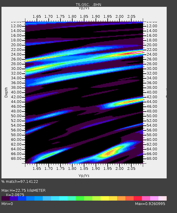
| Estimated Moho Depth: |
22.75 km |
| Estimated Crust Vp/Vs: |
2.10 |
| Assumed Crust Vp: |
6.276 km/s |
| Estimated Crust Vs: |
2.992 km/s |
| Estimated Crust Poisson's Ratio: |
0.35 |
|
| Radial Match: |
97.14122 % |
| Radial Bump: |
386 |
| Transverse Match: |
89.10285 % |
| Transverse Bump: |
400 |
| SOD ConfigId: |
6273 |
| Insert Time: |
2010-02-26 14:16:57.543 +0000 |
| GWidth: |
2.5 |
| Max Bumps: |
400 |
| Tol: |
0.001 |
|

Signal To Noise
| Channel | StoN | STA | LTA |
| TS:GSC: :BHN:19951003T02:00:04.363Z | 1.2962208 | 3.156434E-7 | 2.435105E-7 |
| TS:GSC: :BHE:19951003T02:00:04.363Z | 1.6227225 | 2.4746936E-7 | 1.5250257E-7 |
| TS:GSC: :BHZ:19951003T02:00:04.363Z | 7.8513093 | 7.5282617E-7 | 9.5885426E-8 |
| Arrivals |
| Ps | 4.2 SECOND |
| PpPs | 11 SECOND |
| PsPs/PpSs | 15 SECOND |


