You are here: Home > Network List > TM - Thai Seismic Monitoring Network Stations List
> Station MHIT MHIT Phase1 > Earthquake Result Viewer
MHIT MHIT Phase1 - Earthquake Result Viewer
| Earthquake location: |
Near West Coast Of Honshu, Japan |
| Earthquake latitude/longitude: |
38.6/139.5 |
| Earthquake time(UTC): |
2019/06/18 (169) 13:22:19 GMT |
| Earthquake Depth: |
12 km |
| Earthquake Magnitude: |
6.4 Mww |
| Earthquake Catalog/Contributor: |
NEIC PDE/us |
|
| Network: |
TM Thai Seismic Monitoring Network |
| Station: |
MHIT MHIT Phase1 |
| Lat/Lon: |
19.31 N/97.96 E |
| Elevation: |
270 m |
|
| Distance: |
40.7 deg |
| Az: |
253.753 deg |
| Baz: |
52.754 deg |
| Ray Param: |
0.07425018 |
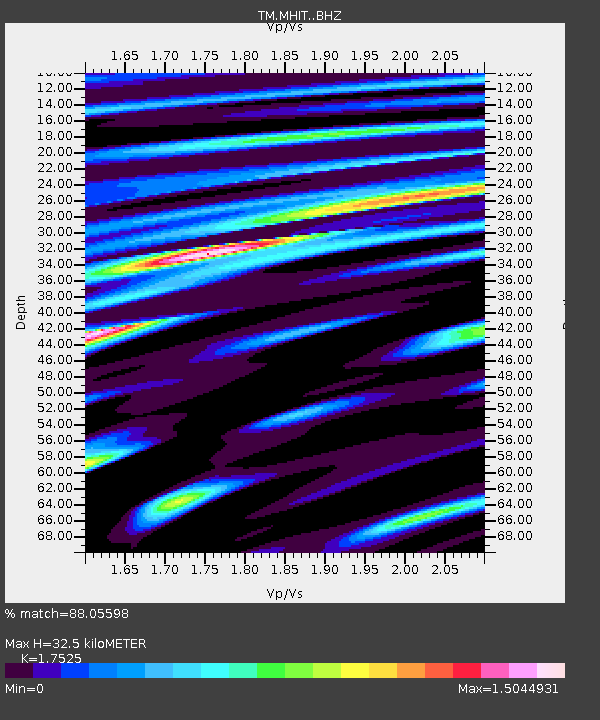
| Estimated Moho Depth: |
32.5 km |
| Estimated Crust Vp/Vs: |
1.75 |
| Assumed Crust Vp: |
6.316 km/s |
| Estimated Crust Vs: |
3.604 km/s |
| Estimated Crust Poisson's Ratio: |
0.26 |
|
| Radial Match: |
88.05598 % |
| Radial Bump: |
400 |
| Transverse Match: |
98.84695 % |
| Transverse Bump: |
86 |
| SOD ConfigId: |
18369291 |
| Insert Time: |
2019-07-02 13:34:27.487 +0000 |
| GWidth: |
2.5 |
| Max Bumps: |
400 |
| Tol: |
0.001 |
|

Signal To Noise
| Channel | StoN | STA | LTA |
| TM:MHIT: :BHZ:20190618T13:29:28.339996Z | 6.300871 | 7.273692E-7 | 1.1543946E-7 |
| TM:MHIT: :BHN:20190618T13:29:28.339996Z | 4.9207864 | 7.4352363E-7 | 1.5109853E-7 |
| TM:MHIT: :BHE:20190618T13:29:28.339996Z | 2.1495538 | 2.753516E-7 | 1.2809708E-7 |
| Arrivals |
| Ps | 4.1 SECOND |
| PpPs | 13 SECOND |
| PsPs/PpSs | 17 SECOND |


