You are here: Home > Network List > TX - Texas Seismological Network Stations List
> Station HNDO Hondo > Earthquake Result Viewer
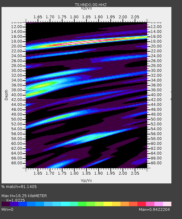
HNDO Hondo - Earthquake Result Viewer
| Earthquake location: |
Near West Coast Of Honshu, Japan |
| Earthquake latitude/longitude: |
38.6/139.5 |
| Earthquake time(UTC): |
2019/06/18 (169) 13:22:19 GMT |
| Earthquake Depth: |
12 km |
| Earthquake Magnitude: |
6.4 Mww |
| Earthquake Catalog/Contributor: |
NEIC PDE/us |
|
| Network: |
TX Texas Seismological Network |
| Station: |
HNDO Hondo |
| Lat/Lon: |
29.53 N/99.28 W |
| Elevation: |
381 m |
|
| Distance: |
92.8 deg |
| Az: |
48.245 deg |
| Baz: |
317.912 deg |
| Ray Param: |
0.041383952 |
| Estimated Moho Depth: |
18.25 km |
| Estimated Crust Vp/Vs: |
1.82 |
| Assumed Crust Vp: |
6.347 km/s |
| Estimated Crust Vs: |
3.483 km/s |
| Estimated Crust Poisson's Ratio: |
0.28 |
|
| Radial Match: |
91.1405 % |
| Radial Bump: |
400 |
| Transverse Match: |
84.29708 % |
| Transverse Bump: |
400 |
| SOD ConfigId: |
18369291 |
| Insert Time: |
2019-07-02 13:34:39.876 +0000 |
| GWidth: |
2.5 |
| Max Bumps: |
400 |
| Tol: |
0.001 |
|

Signal To Noise
| Channel | StoN | STA | LTA |
| TX:HNDO:00:HHZ:20190618T13:34:59.669982Z | 5.0071344 | 3.3039203E-7 | 6.598425E-8 |
| TX:HNDO:00:HH1:20190618T13:34:59.669982Z | 1.4789371 | 4.633352E-8 | 3.132893E-8 |
| TX:HNDO:00:HH2:20190618T13:34:59.669982Z | 2.706592 | 1.2158682E-7 | 4.4922476E-8 |
| Arrivals |
| Ps | 2.4 SECOND |
| PpPs | 8.0 SECOND |
| PsPs/PpSs | 10 SECOND |


