You are here: Home > Network List > TX - Texas Seismological Network Stations List
> Station PLPT Palo Pinto > Earthquake Result Viewer
PLPT Palo Pinto - Earthquake Result Viewer
| Earthquake location: |
Near West Coast Of Honshu, Japan |
| Earthquake latitude/longitude: |
38.6/139.5 |
| Earthquake time(UTC): |
2019/06/18 (169) 13:22:19 GMT |
| Earthquake Depth: |
12 km |
| Earthquake Magnitude: |
6.4 Mww |
| Earthquake Catalog/Contributor: |
NEIC PDE/us |
|
| Network: |
TX Texas Seismological Network |
| Station: |
PLPT Palo Pinto |
| Lat/Lon: |
32.81 N/98.32 W |
| Elevation: |
336 m |
|
| Distance: |
90.9 deg |
| Az: |
45.445 deg |
| Baz: |
318.5 deg |
| Ray Param: |
0.04163862 |
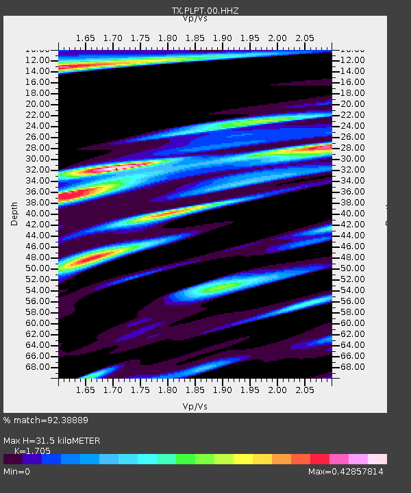
| Estimated Moho Depth: |
31.5 km |
| Estimated Crust Vp/Vs: |
1.71 |
| Assumed Crust Vp: |
6.426 km/s |
| Estimated Crust Vs: |
3.769 km/s |
| Estimated Crust Poisson's Ratio: |
0.24 |
|
| Radial Match: |
92.38889 % |
| Radial Bump: |
316 |
| Transverse Match: |
82.26533 % |
| Transverse Bump: |
400 |
| SOD ConfigId: |
18369291 |
| Insert Time: |
2019-07-02 13:34:49.904 +0000 |
| GWidth: |
2.5 |
| Max Bumps: |
400 |
| Tol: |
0.001 |
|

Signal To Noise
| Channel | StoN | STA | LTA |
| TX:PLPT:00:HHZ:20190618T13:34:50.955017Z | 7.061562 | 5.5665754E-7 | 7.882924E-8 |
| TX:PLPT:00:HH1:20190618T13:34:50.955017Z | 1.8714316 | 1.01242364E-7 | 5.4098884E-8 |
| TX:PLPT:00:HH2:20190618T13:34:50.955017Z | 3.8416073 | 1.5971732E-7 | 4.157565E-8 |
| Arrivals |
| Ps | 3.5 SECOND |
| PpPs | 13 SECOND |
| PsPs/PpSs | 17 SECOND |


