You are here: Home > Network List > US - United States National Seismic Network Stations List
> Station BMO Blue Mountains Array (Baker), Oregon, USA > Earthquake Result Viewer
BMO Blue Mountains Array (Baker), Oregon, USA - Earthquake Result Viewer

| Earthquake location: |
Near West Coast Of Honshu, Japan |
| Earthquake latitude/longitude: |
38.6/139.5 |
| Earthquake time(UTC): |
2019/06/18 (169) 13:22:19 GMT |
| Earthquake Depth: |
12 km |
| Earthquake Magnitude: |
6.4 Mww |
| Earthquake Catalog/Contributor: |
NEIC PDE/us |
|
| Network: |
US United States National Seismic Network |
| Station: |
BMO Blue Mountains Array (Baker), Oregon, USA |
| Lat/Lon: |
44.85 N/117.31 W |
| Elevation: |
1189 m |
|
| Distance: |
72.0 deg |
| Az: |
46.743 deg |
| Baz: |
306.705 deg |
| Ray Param: |
0.053977508 |
| Estimated Moho Depth: |
28.5 km |
| Estimated Crust Vp/Vs: |
1.81 |
| Assumed Crust Vp: |
6.571 km/s |
| Estimated Crust Vs: |
3.63 km/s |
| Estimated Crust Poisson's Ratio: |
0.28 |
|
| Radial Match: |
95.193085 % |
| Radial Bump: |
400 |
| Transverse Match: |
91.74692 % |
| Transverse Bump: |
400 |
| SOD ConfigId: |
18369291 |
| Insert Time: |
2019-07-02 13:35:11.336 +0000 |
| GWidth: |
2.5 |
| Max Bumps: |
400 |
| Tol: |
0.001 |
|
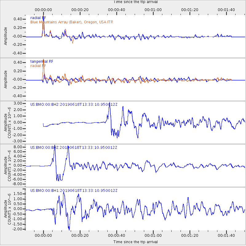
Signal To Noise
| Channel | StoN | STA | LTA |
| US:BMO:00:BHZ:20190618T13:33:10.950012Z | 12.34218 | 7.335436E-7 | 5.9433876E-8 |
| US:BMO:00:BH1:20190618T13:33:10.950012Z | 0.93767464 | 6.244786E-8 | 6.6598645E-8 |
| US:BMO:00:BH2:20190618T13:33:10.950012Z | 1.5075444 | 3.0455746E-7 | 2.020222E-7 |
| Arrivals |
| Ps | 3.6 SECOND |
| PpPs | 12 SECOND |
| PsPs/PpSs | 15 SECOND |


