You are here: Home > Network List > US - United States National Seismic Network Stations List
> Station MSO Missoula, Montana, USA > Earthquake Result Viewer
MSO Missoula, Montana, USA - Earthquake Result Viewer
| Earthquake location: |
Near West Coast Of Honshu, Japan |
| Earthquake latitude/longitude: |
38.6/139.5 |
| Earthquake time(UTC): |
2019/06/18 (169) 13:22:19 GMT |
| Earthquake Depth: |
12 km |
| Earthquake Magnitude: |
6.4 Mww |
| Earthquake Catalog/Contributor: |
NEIC PDE/us |
|
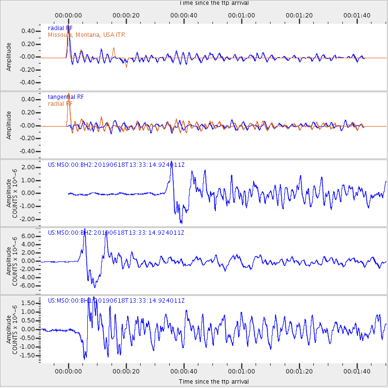
| Network: |
US United States National Seismic Network |
| Station: |
MSO Missoula, Montana, USA |
| Lat/Lon: |
46.83 N/113.94 W |
| Elevation: |
1264 m |
|
| Distance: |
72.6 deg |
| Az: |
43.592 deg |
| Baz: |
308.153 deg |
| Ray Param: |
0.053535733 |
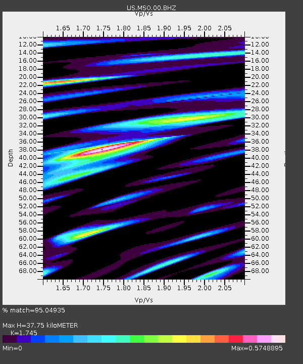
| Estimated Moho Depth: |
37.75 km |
| Estimated Crust Vp/Vs: |
1.75 |
| Assumed Crust Vp: |
6.353 km/s |
| Estimated Crust Vs: |
3.641 km/s |
| Estimated Crust Poisson's Ratio: |
0.26 |
|
| Radial Match: |
95.04935 % |
| Radial Bump: |
400 |
| Transverse Match: |
83.47891 % |
| Transverse Bump: |
400 |
| SOD ConfigId: |
18369291 |
| Insert Time: |
2019-07-02 13:35:26.584 +0000 |
| GWidth: |
2.5 |
| Max Bumps: |
400 |
| Tol: |
0.001 |
|
Signal To Noise
| Channel | StoN | STA | LTA |
| US:MSO:00:BHZ:20190618T13:33:14.924011Z | 16.876797 | 9.570083E-7 | 5.6705563E-8 |
| US:MSO:00:BH1:20190618T13:33:14.924011Z | 5.4900804 | 2.2992892E-7 | 4.1880792E-8 |
| US:MSO:00:BH2:20190618T13:33:14.924011Z | 6.20782 | 3.0869742E-7 | 4.9727184E-8 |
| Arrivals |
| Ps | 4.6 SECOND |
| PpPs | 16 SECOND |
| PsPs/PpSs | 20 SECOND |


