You are here: Home > Network List > UU - University of Utah Regional Network Stations List
> Station CTU Camp Tracy, UT, USA > Earthquake Result Viewer
CTU Camp Tracy, UT, USA - Earthquake Result Viewer
| Earthquake location: |
Near West Coast Of Honshu, Japan |
| Earthquake latitude/longitude: |
38.6/139.5 |
| Earthquake time(UTC): |
2019/06/18 (169) 13:22:19 GMT |
| Earthquake Depth: |
12 km |
| Earthquake Magnitude: |
6.4 Mww |
| Earthquake Catalog/Contributor: |
NEIC PDE/us |
|
| Network: |
UU University of Utah Regional Network |
| Station: |
CTU Camp Tracy, UT, USA |
| Lat/Lon: |
40.69 N/111.75 W |
| Elevation: |
1731 m |
|
| Distance: |
77.7 deg |
| Az: |
47.451 deg |
| Baz: |
310.653 deg |
| Ray Param: |
0.0501105 |
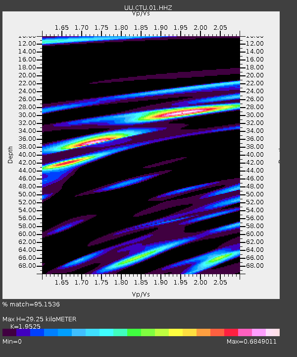
| Estimated Moho Depth: |
29.25 km |
| Estimated Crust Vp/Vs: |
1.95 |
| Assumed Crust Vp: |
6.155 km/s |
| Estimated Crust Vs: |
3.152 km/s |
| Estimated Crust Poisson's Ratio: |
0.32 |
|
| Radial Match: |
95.1536 % |
| Radial Bump: |
378 |
| Transverse Match: |
85.09401 % |
| Transverse Bump: |
400 |
| SOD ConfigId: |
18369291 |
| Insert Time: |
2019-07-02 13:35:37.674 +0000 |
| GWidth: |
2.5 |
| Max Bumps: |
400 |
| Tol: |
0.001 |
|

Signal To Noise
| Channel | StoN | STA | LTA |
| UU:CTU:01:HHZ:20190618T13:33:44.35498Z | 4.367461 | 1.0775535E-8 | 2.4672309E-9 |
| UU:CTU:01:HHN:20190618T13:33:44.35498Z | 2.1308422 | 3.0516056E-9 | 1.4321124E-9 |
| UU:CTU:01:HHE:20190618T13:33:44.35498Z | 2.08097 | 2.559837E-9 | 1.2301172E-9 |
| Arrivals |
| Ps | 4.6 SECOND |
| PpPs | 14 SECOND |
| PsPs/PpSs | 18 SECOND |


