You are here: Home > Network List > TA - USArray Transportable Network (new EarthScope stations) Stations List
> Station C17A Wharram Farm, Highwood, MT, USA > Earthquake Result Viewer
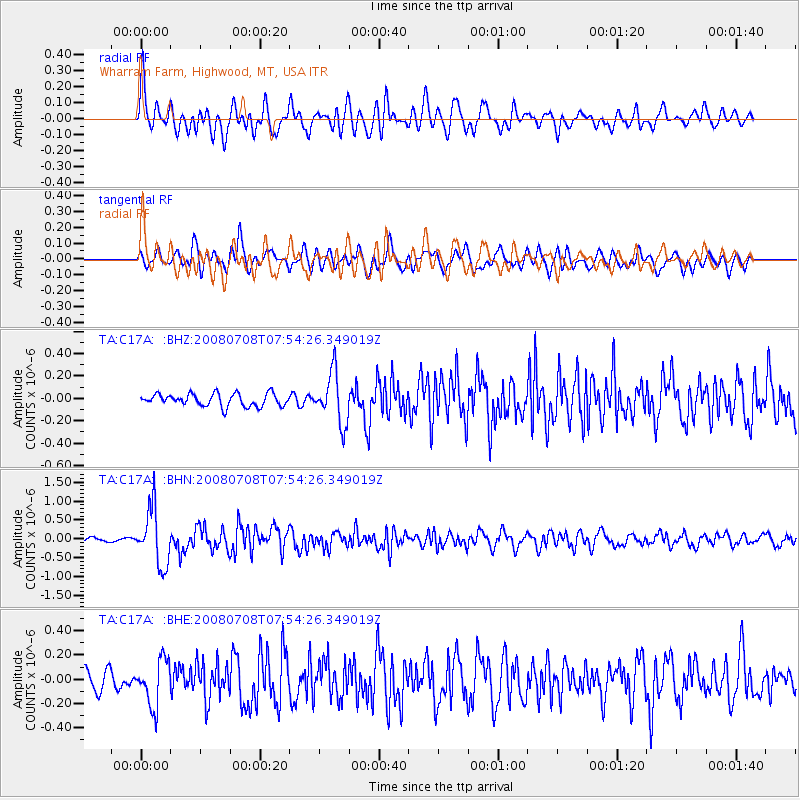
C17A Wharram Farm, Highwood, MT, USA - Earthquake Result Viewer
*The percent match for this event was below the threshold and hence no stack was calculated.
| Earthquake location: |
Ryukyu Islands, Japan |
| Earthquake latitude/longitude: |
27.5/128.3 |
| Earthquake time(UTC): |
2008/07/08 (190) 07:42:10 GMT |
| Earthquake Depth: |
43 km |
| Earthquake Magnitude: |
6.0 MB, 5.5 MS, 6.0 MW, 6.0 MW |
| Earthquake Catalog/Contributor: |
WHDF/NEIC |
|
| Network: |
TA USArray Transportable Network (new EarthScope stations) |
| Station: |
C17A Wharram Farm, Highwood, MT, USA |
| Lat/Lon: |
47.63 N/110.76 W |
| Elevation: |
1080 m |
|
| Distance: |
88.3 deg |
| Az: |
35.492 deg |
| Baz: |
310.333 deg |
| Ray Param: |
$rayparam |
*The percent match for this event was below the threshold and hence was not used in the summary stack. |
|
| Radial Match: |
79.47324 % |
| Radial Bump: |
400 |
| Transverse Match: |
68.17659 % |
| Transverse Bump: |
400 |
| SOD ConfigId: |
2504 |
| Insert Time: |
2010-03-07 00:07:35.553 +0000 |
| GWidth: |
2.5 |
| Max Bumps: |
400 |
| Tol: |
0.001 |
|
Signal To Noise
| Channel | StoN | STA | LTA |
| TA:C17A: :BHN:20080708T07:54:26.349019Z | 11.693797 | 7.50597E-7 | 6.418762E-8 |
| TA:C17A: :BHE:20080708T07:54:26.349019Z | 3.2198353 | 1.8797884E-7 | 5.838151E-8 |
| TA:C17A: :BHZ:20080708T07:54:26.349019Z | 4.054213 | 2.2482062E-7 | 5.5453583E-8 |
| Arrivals |
| Ps | |
| PpPs | |
| PsPs/PpSs | |


