You are here: Home > Network List > IU - Global Seismograph Network (GSN - IRIS/USGS) Stations List
> Station PMG Port Moresby, New Guinea > Earthquake Result Viewer
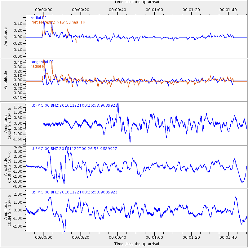
PMG Port Moresby, New Guinea - Earthquake Result Viewer
*The percent match for this event was below the threshold and hence no stack was calculated.
| Earthquake location: |
Off E. Coast Of N. Island, N.Z. |
| Earthquake latitude/longitude: |
-40.6/177.1 |
| Earthquake time(UTC): |
2016/11/22 (327) 00:19:42 GMT |
| Earthquake Depth: |
9.6 km |
| Earthquake Magnitude: |
5.9 MWW |
| Earthquake Catalog/Contributor: |
NEIC PDE/NEIC COMCAT |
|
| Network: |
IU Global Seismograph Network (GSN - IRIS/USGS) |
| Station: |
PMG Port Moresby, New Guinea |
| Lat/Lon: |
9.40 S/147.16 E |
| Elevation: |
90 m |
|
| Distance: |
40.8 deg |
| Az: |
311.176 deg |
| Baz: |
144.485 deg |
| Ray Param: |
$rayparam |
*The percent match for this event was below the threshold and hence was not used in the summary stack. |
|
| Radial Match: |
84.34662 % |
| Radial Bump: |
400 |
| Transverse Match: |
72.37229 % |
| Transverse Bump: |
400 |
| SOD ConfigId: |
1858631 |
| Insert Time: |
2016-12-06 00:21:44.333 +0000 |
| GWidth: |
2.5 |
| Max Bumps: |
400 |
| Tol: |
0.001 |
|
Signal To Noise
| Channel | StoN | STA | LTA |
| IU:PMG:00:BHZ:20161122T00:26:53.968992Z | 7.337003 | 1.4819783E-6 | 2.0198688E-7 |
| IU:PMG:00:BH1:20161122T00:26:53.968992Z | 3.486787 | 8.898447E-7 | 2.5520475E-7 |
| IU:PMG:00:BH2:20161122T00:26:53.968992Z | 2.5255477 | 4.418024E-7 | 1.749333E-7 |
| Arrivals |
| Ps | |
| PpPs | |
| PsPs/PpSs | |


