You are here: Home > Network List > G - GEOSCOPE Stations List
> Station INU Inuyama, Japan > Earthquake Result Viewer
INU Inuyama, Japan - Earthquake Result Viewer

| Earthquake location: |
Kermadec Islands, New Zealand |
| Earthquake latitude/longitude: |
-30.8/-177.4 |
| Earthquake time(UTC): |
2019/06/19 (170) 07:01:40 GMT |
| Earthquake Depth: |
10 km |
| Earthquake Magnitude: |
6.8 Mi |
| Earthquake Catalog/Contributor: |
NEIC PDE/at |
|
| Network: |
G GEOSCOPE |
| Station: |
INU Inuyama, Japan |
| Lat/Lon: |
35.35 N/137.03 E |
| Elevation: |
132 m |
|
| Distance: |
78.5 deg |
| Az: |
323.44 deg |
| Baz: |
141.17 deg |
| Ray Param: |
0.04958175 |
| Estimated Moho Depth: |
56.0 km |
| Estimated Crust Vp/Vs: |
1.68 |
| Assumed Crust Vp: |
6.461 km/s |
| Estimated Crust Vs: |
3.84 km/s |
| Estimated Crust Poisson's Ratio: |
0.23 |
|
| Radial Match: |
92.76654 % |
| Radial Bump: |
400 |
| Transverse Match: |
85.55976 % |
| Transverse Bump: |
400 |
| SOD ConfigId: |
18369291 |
| Insert Time: |
2019-07-03 07:04:37.876 +0000 |
| GWidth: |
2.5 |
| Max Bumps: |
400 |
| Tol: |
0.001 |
|
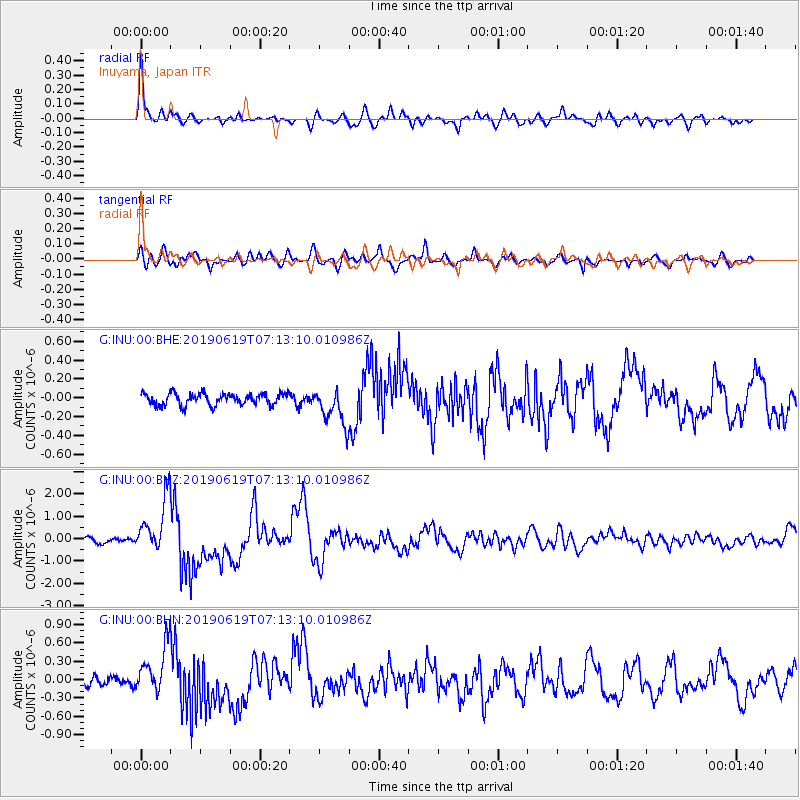
Signal To Noise
| Channel | StoN | STA | LTA |
| G:INU:00:BHZ:20190619T07:13:10.010986Z | 12.816014 | 1.2432472E-6 | 9.7007316E-8 |
| G:INU:00:BHN:20190619T07:13:10.010986Z | 5.6275635 | 4.000429E-7 | 7.108634E-8 |
| G:INU:00:BHE:20190619T07:13:10.010986Z | 3.2240746 | 1.9907279E-7 | 6.1745716E-8 |
| Arrivals |
| Ps | 6.1 SECOND |
| PpPs | 23 SECOND |
| PsPs/PpSs | 29 SECOND |


