You are here: Home > Network List > TA - USArray Transportable Network (new EarthScope stations) Stations List
> Station Q20K Shuyak Island, AK, USA > Earthquake Result Viewer
Q20K Shuyak Island, AK, USA - Earthquake Result Viewer
| Earthquake location: |
Kermadec Islands, New Zealand |
| Earthquake latitude/longitude: |
-30.8/-177.4 |
| Earthquake time(UTC): |
2019/06/19 (170) 07:01:40 GMT |
| Earthquake Depth: |
10 km |
| Earthquake Magnitude: |
6.8 Mi |
| Earthquake Catalog/Contributor: |
NEIC PDE/at |
|
| Network: |
TA USArray Transportable Network (new EarthScope stations) |
| Station: |
Q20K Shuyak Island, AK, USA |
| Lat/Lon: |
58.61 N/152.39 W |
| Elevation: |
180 m |
|
| Distance: |
91.5 deg |
| Az: |
12.787 deg |
| Baz: |
201.337 deg |
| Ray Param: |
0.041598458 |
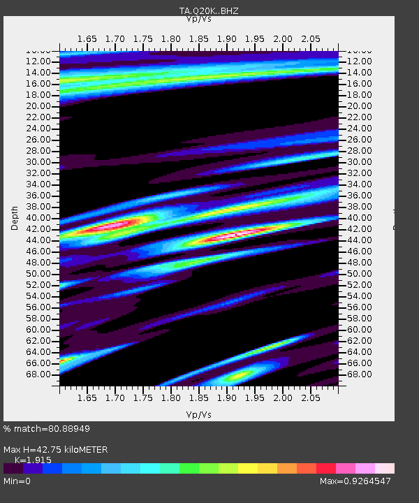
| Estimated Moho Depth: |
42.75 km |
| Estimated Crust Vp/Vs: |
1.91 |
| Assumed Crust Vp: |
5.989 km/s |
| Estimated Crust Vs: |
3.127 km/s |
| Estimated Crust Poisson's Ratio: |
0.31 |
|
| Radial Match: |
80.88949 % |
| Radial Bump: |
400 |
| Transverse Match: |
71.88335 % |
| Transverse Bump: |
400 |
| SOD ConfigId: |
18369291 |
| Insert Time: |
2019-07-03 07:06:50.046 +0000 |
| GWidth: |
2.5 |
| Max Bumps: |
400 |
| Tol: |
0.001 |
|

Signal To Noise
| Channel | StoN | STA | LTA |
| TA:Q20K: :BHZ:20190619T07:14:14.900024Z | 1.8818799 | 3.3178375E-7 | 1.7630443E-7 |
| TA:Q20K: :BHN:20190619T07:14:14.900024Z | 1.2749319 | 1.8727086E-7 | 1.4688695E-7 |
| TA:Q20K: :BHE:20190619T07:14:14.900024Z | 0.85708976 | 1.607018E-7 | 1.8749704E-7 |
| Arrivals |
| Ps | 6.6 SECOND |
| PpPs | 20 SECOND |
| PsPs/PpSs | 27 SECOND |


