You are here: Home > Network List > TA - USArray Transportable Network (new EarthScope stations) Stations List
> Station B21A Ellsworth Farm, Hinsdale, MT, USA > Earthquake Result Viewer
B21A Ellsworth Farm, Hinsdale, MT, USA - Earthquake Result Viewer
| Earthquake location: |
Tonga Islands |
| Earthquake latitude/longitude: |
-20.8/-174.3 |
| Earthquake time(UTC): |
2009/07/30 (211) 20:05:34 GMT |
| Earthquake Depth: |
10 km |
| Earthquake Magnitude: |
5.9 MB, 5.7 MS, 5.8 MW, 5.7 MW |
| Earthquake Catalog/Contributor: |
WHDF/NEIC |
|
| Network: |
TA USArray Transportable Network (new EarthScope stations) |
| Station: |
B21A Ellsworth Farm, Hinsdale, MT, USA |
| Lat/Lon: |
48.43 N/107.02 W |
| Elevation: |
661 m |
|
| Distance: |
91.3 deg |
| Az: |
37.904 deg |
| Baz: |
239.62 deg |
| Ray Param: |
0.041611195 |
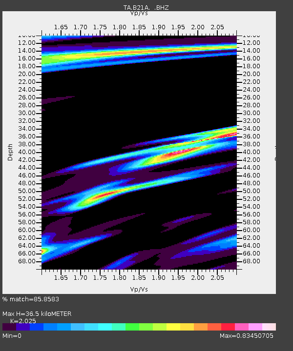
| Estimated Moho Depth: |
36.5 km |
| Estimated Crust Vp/Vs: |
2.03 |
| Assumed Crust Vp: |
6.438 km/s |
| Estimated Crust Vs: |
3.179 km/s |
| Estimated Crust Poisson's Ratio: |
0.34 |
|
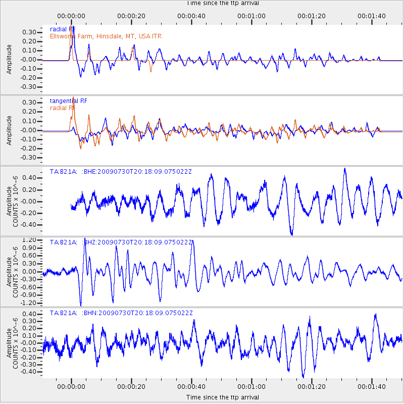
| Radial Match: |
85.8583 % |
| Radial Bump: |
356 |
| Transverse Match: |
64.32202 % |
| Transverse Bump: |
400 |
| SOD ConfigId: |
2622 |
| Insert Time: |
2010-03-07 00:10:01.405 +0000 |
| GWidth: |
2.5 |
| Max Bumps: |
400 |
| Tol: |
0.001 |
|
Signal To Noise
| Channel | StoN | STA | LTA |
| TA:B21A: :BHZ:20090730T20:18:09.075022Z | 7.7737546 | 5.6153306E-7 | 7.2234464E-8 |
| TA:B21A: :BHN:20090730T20:18:09.075022Z | 0.9769787 | 1.023949E-7 | 1.0480771E-7 |
| TA:B21A: :BHE:20090730T20:18:09.075022Z | 1.732651 | 1.3859244E-7 | 7.9988666E-8 |
| Arrivals |
| Ps | 5.9 SECOND |
| PpPs | 17 SECOND |
| PsPs/PpSs | 23 SECOND |


