You are here: Home > Network List > IW - Intermountain West Stations List
> Station IMW Indian Meadow, Wyoming, USA > Earthquake Result Viewer
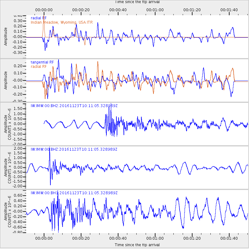
IMW Indian Meadow, Wyoming, USA - Earthquake Result Viewer
*The percent match for this event was below the threshold and hence no stack was calculated.
| Earthquake location: |
Bonin Islands, Japan Region |
| Earthquake latitude/longitude: |
27.2/140.0 |
| Earthquake time(UTC): |
2016/11/23 (328) 09:59:56 GMT |
| Earthquake Depth: |
477 km |
| Earthquake Magnitude: |
5.7 MB |
| Earthquake Catalog/Contributor: |
NEIC PDE/NEIC COMCAT |
|
| Network: |
IW Intermountain West |
| Station: |
IMW Indian Meadow, Wyoming, USA |
| Lat/Lon: |
43.90 N/110.94 W |
| Elevation: |
2646 m |
|
| Distance: |
84.1 deg |
| Az: |
43.399 deg |
| Baz: |
302.129 deg |
| Ray Param: |
$rayparam |
*The percent match for this event was below the threshold and hence was not used in the summary stack. |
|
| Radial Match: |
53.677742 % |
| Radial Bump: |
400 |
| Transverse Match: |
60.08261 % |
| Transverse Bump: |
400 |
| SOD ConfigId: |
1858631 |
| Insert Time: |
2016-12-07 10:01:54.605 +0000 |
| GWidth: |
2.5 |
| Max Bumps: |
400 |
| Tol: |
0.001 |
|
Signal To Noise
| Channel | StoN | STA | LTA |
| IW:IMW:00:BHZ:20161123T10:11:05.328989Z | 1.9518083 | 6.4141113E-7 | 3.2862405E-7 |
| IW:IMW:00:BH1:20161123T10:11:05.328989Z | 1.4285141 | 2.1920171E-7 | 1.5344735E-7 |
| IW:IMW:00:BH2:20161123T10:11:05.328989Z | 1.7180084 | 4.042057E-7 | 2.3527575E-7 |
| Arrivals |
| Ps | |
| PpPs | |
| PsPs/PpSs | |


