You are here: Home > Network List > TA - USArray Transportable Network (new EarthScope stations) Stations List
> Station B21A Ellsworth Farm, Hinsdale, MT, USA > Earthquake Result Viewer
B21A Ellsworth Farm, Hinsdale, MT, USA - Earthquake Result Viewer
| Earthquake location: |
Tonga Islands |
| Earthquake latitude/longitude: |
-16.3/-173.5 |
| Earthquake time(UTC): |
2009/10/02 (275) 01:07:39 GMT |
| Earthquake Depth: |
8.0 km |
| Earthquake Magnitude: |
6.1 MB, 6.0 MS, 6.1 MW, 6.1 MW |
| Earthquake Catalog/Contributor: |
WHDF/NEIC |
|
| Network: |
TA USArray Transportable Network (new EarthScope stations) |
| Station: |
B21A Ellsworth Farm, Hinsdale, MT, USA |
| Lat/Lon: |
48.43 N/107.02 W |
| Elevation: |
661 m |
|
| Distance: |
87.3 deg |
| Az: |
37.682 deg |
| Baz: |
241.784 deg |
| Ray Param: |
0.04341939 |
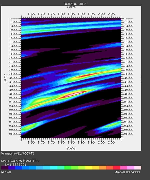
| Estimated Moho Depth: |
47.75 km |
| Estimated Crust Vp/Vs: |
1.87 |
| Assumed Crust Vp: |
6.438 km/s |
| Estimated Crust Vs: |
3.447 km/s |
| Estimated Crust Poisson's Ratio: |
0.30 |
|
| Radial Match: |
81.700745 % |
| Radial Bump: |
310 |
| Transverse Match: |
69.051575 % |
| Transverse Bump: |
381 |
| SOD ConfigId: |
2622 |
| Insert Time: |
2010-03-07 00:10:16.136 +0000 |
| GWidth: |
2.5 |
| Max Bumps: |
400 |
| Tol: |
0.001 |
|
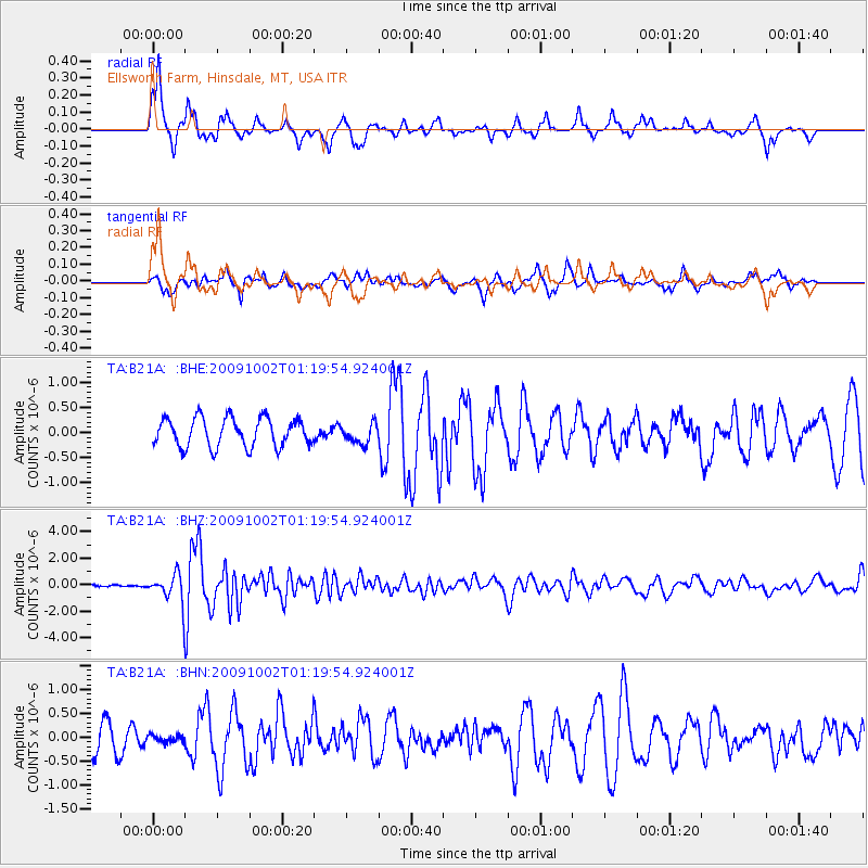
Signal To Noise
| Channel | StoN | STA | LTA |
| TA:B21A: :BHZ:20091002T01:19:54.924001Z | 7.9194293 | 1.0629873E-6 | 1.3422523E-7 |
| TA:B21A: :BHN:20091002T01:19:54.924001Z | 0.29418406 | 7.135136E-8 | 2.4253984E-7 |
| TA:B21A: :BHE:20091002T01:19:54.924001Z | 0.69806284 | 1.9737945E-7 | 2.8275315E-7 |
| Arrivals |
| Ps | 6.6 SECOND |
| PpPs | 21 SECOND |
| PsPs/PpSs | 27 SECOND |


