You are here: Home > Network List > TA - USArray Transportable Network (new EarthScope stations) Stations List
> Station B21A Ellsworth Farm, Hinsdale, MT, USA > Earthquake Result Viewer
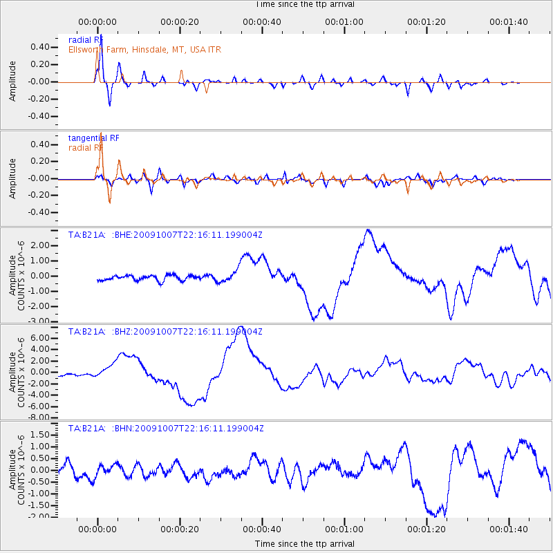
B21A Ellsworth Farm, Hinsdale, MT, USA - Earthquake Result Viewer
| Earthquake location: |
Vanuatu Islands |
| Earthquake latitude/longitude: |
-13.0/166.5 |
| Earthquake time(UTC): |
2009/10/07 (280) 22:03:14 GMT |
| Earthquake Depth: |
45 km |
| Earthquake Magnitude: |
6.4 MB, 7.3 MS, 7.6 MW, 7.7 MW |
| Earthquake Catalog/Contributor: |
WHDF/NEIC |
|
| Network: |
TA USArray Transportable Network (new EarthScope stations) |
| Station: |
B21A Ellsworth Farm, Hinsdale, MT, USA |
| Lat/Lon: |
48.43 N/107.02 W |
| Elevation: |
661 m |
|
| Distance: |
97.3 deg |
| Az: |
42.083 deg |
| Baz: |
258.741 deg |
| Ray Param: |
0.040232234 |
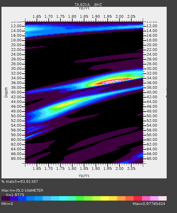
| Estimated Moho Depth: |
35.0 km |
| Estimated Crust Vp/Vs: |
1.98 |
| Assumed Crust Vp: |
6.438 km/s |
| Estimated Crust Vs: |
3.255 km/s |
| Estimated Crust Poisson's Ratio: |
0.33 |
|
| Radial Match: |
93.91387 % |
| Radial Bump: |
371 |
| Transverse Match: |
76.09949 % |
| Transverse Bump: |
400 |
| SOD ConfigId: |
2622 |
| Insert Time: |
2010-03-07 00:10:17.855 +0000 |
| GWidth: |
2.5 |
| Max Bumps: |
400 |
| Tol: |
0.001 |
|
Signal To Noise
| Channel | StoN | STA | LTA |
| TA:B21A: :BHZ:20091007T22:16:11.199004Z | 4.761495 | 1.3036163E-6 | 2.7378297E-7 |
| TA:B21A: :BHN:20091007T22:16:11.199004Z | 0.7381369 | 2.3356537E-7 | 3.1642554E-7 |
| TA:B21A: :BHE:20091007T22:16:11.199004Z | 2.6318371 | 4.463391E-7 | 1.6959221E-7 |
| Arrivals |
| Ps | 5.4 SECOND |
| PpPs | 16 SECOND |
| PsPs/PpSs | 21 SECOND |


