You are here: Home > Network List > TS - TERRAscope (Southern California Seismic Network) Stations List
> Station GSC Goldston, California, USA > Earthquake Result Viewer
GSC Goldston, California, USA - Earthquake Result Viewer
| Earthquake location: |
Colombia |
| Earthquake latitude/longitude: |
4.2/-76.6 |
| Earthquake time(UTC): |
1995/02/08 (039) 18:40:25 GMT |
| Earthquake Depth: |
69 km |
| Earthquake Magnitude: |
6.3 MB, 6.4 UNKNOWN, 6.0 MD |
| Earthquake Catalog/Contributor: |
WHDF/NEIC |
|
| Network: |
TS TERRAscope (Southern California Seismic Network) |
| Station: |
GSC Goldston, California, USA |
| Lat/Lon: |
35.30 N/116.81 W |
| Elevation: |
990 m |
|
| Distance: |
48.3 deg |
| Az: |
315.065 deg |
| Baz: |
120.54 deg |
| Ray Param: |
0.069226064 |
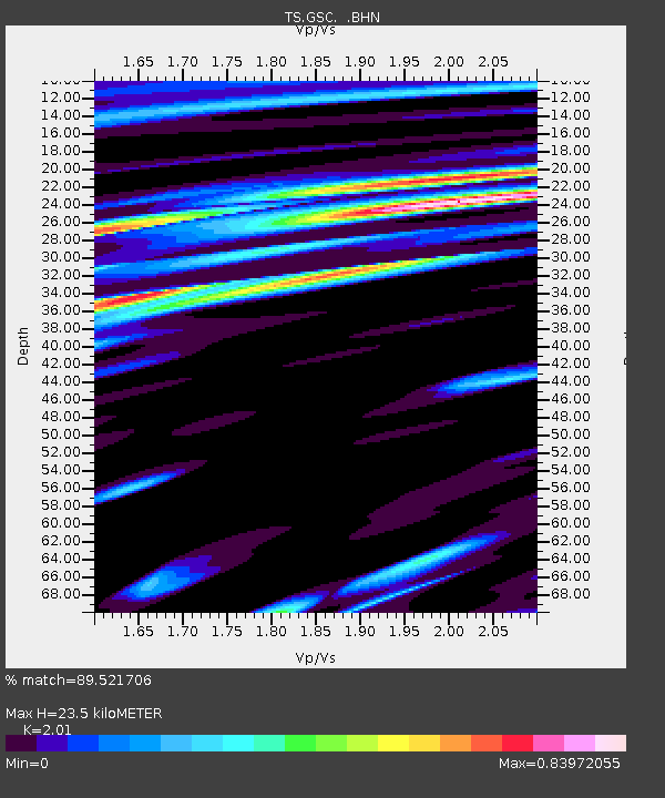
| Estimated Moho Depth: |
23.5 km |
| Estimated Crust Vp/Vs: |
2.01 |
| Assumed Crust Vp: |
6.276 km/s |
| Estimated Crust Vs: |
3.122 km/s |
| Estimated Crust Poisson's Ratio: |
0.34 |
|
| Radial Match: |
89.521706 % |
| Radial Bump: |
400 |
| Transverse Match: |
74.951866 % |
| Transverse Bump: |
400 |
| SOD ConfigId: |
6273 |
| Insert Time: |
2010-02-26 14:17:18.172 +0000 |
| GWidth: |
2.5 |
| Max Bumps: |
400 |
| Tol: |
0.001 |
|

Signal To Noise
| Channel | StoN | STA | LTA |
| TS:GSC: :BHN:19950208T18:48:29.131006Z | 2.4588156 | 5.8263237E-7 | 2.3695651E-7 |
| TS:GSC: :BHE:19950208T18:48:29.131006Z | 3.76809 | 1.2142498E-6 | 3.2224543E-7 |
| TS:GSC: :BHZ:19950208T18:48:29.131006Z | 14.571354 | 3.4605664E-6 | 2.3749108E-7 |
| Arrivals |
| Ps | 4.0 SECOND |
| PpPs | 11 SECOND |
| PsPs/PpSs | 15 SECOND |


