You are here: Home > Network List > TA - USArray Transportable Network (new EarthScope stations) Stations List
> Station B22K Teshekpuk Lake, AK, USA > Earthquake Result Viewer
B22K Teshekpuk Lake, AK, USA - Earthquake Result Viewer
| Earthquake location: |
Irian Jaya, Indonesia |
| Earthquake latitude/longitude: |
-2.2/138.4 |
| Earthquake time(UTC): |
2019/06/19 (170) 17:24:48 GMT |
| Earthquake Depth: |
10 km |
| Earthquake Magnitude: |
6.3 Mww |
| Earthquake Catalog/Contributor: |
NEIC PDE/us |
|
| Network: |
TA USArray Transportable Network (new EarthScope stations) |
| Station: |
B22K Teshekpuk Lake, AK, USA |
| Lat/Lon: |
70.34 N/153.42 W |
| Elevation: |
50 m |
|
| Distance: |
84.9 deg |
| Az: |
18.385 deg |
| Baz: |
248.622 deg |
| Ray Param: |
0.045165624 |
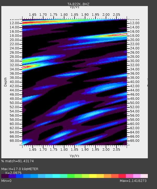
| Estimated Moho Depth: |
17.0 km |
| Estimated Crust Vp/Vs: |
2.10 |
| Assumed Crust Vp: |
5.738 km/s |
| Estimated Crust Vs: |
2.736 km/s |
| Estimated Crust Poisson's Ratio: |
0.35 |
|
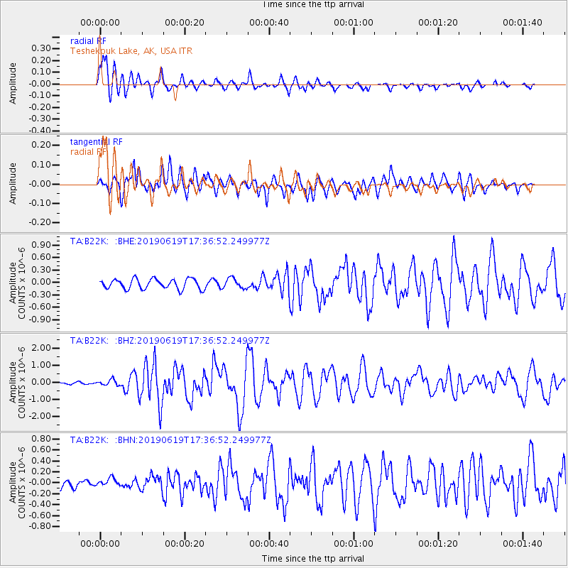
| Radial Match: |
91.43174 % |
| Radial Bump: |
389 |
| Transverse Match: |
81.7173 % |
| Transverse Bump: |
400 |
| SOD ConfigId: |
18369291 |
| Insert Time: |
2019-07-03 17:27:46.047 +0000 |
| GWidth: |
2.5 |
| Max Bumps: |
400 |
| Tol: |
0.001 |
|
Signal To Noise
| Channel | StoN | STA | LTA |
| TA:B22K: :BHZ:20190619T17:36:52.249977Z | 2.9807982 | 1.6418952E-7 | 5.50824E-8 |
| TA:B22K: :BHN:20190619T17:36:52.249977Z | 0.77425456 | 7.342723E-8 | 9.483603E-8 |
| TA:B22K: :BHE:20190619T17:36:52.249977Z | 1.0013832 | 1.2007338E-7 | 1.1990751E-7 |
| Arrivals |
| Ps | 3.3 SECOND |
| PpPs | 9.0 SECOND |
| PsPs/PpSs | 12 SECOND |


