You are here: Home > Network List > TA - USArray Transportable Network (new EarthScope stations) Stations List
> Station D20K Etivluk River, AK, USA > Earthquake Result Viewer
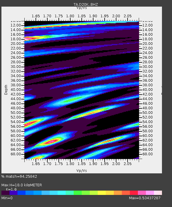
D20K Etivluk River, AK, USA - Earthquake Result Viewer
| Earthquake location: |
Irian Jaya, Indonesia |
| Earthquake latitude/longitude: |
-2.2/138.4 |
| Earthquake time(UTC): |
2019/06/19 (170) 17:24:48 GMT |
| Earthquake Depth: |
10 km |
| Earthquake Magnitude: |
6.3 Mww |
| Earthquake Catalog/Contributor: |
NEIC PDE/us |
|
| Network: |
TA USArray Transportable Network (new EarthScope stations) |
| Station: |
D20K Etivluk River, AK, USA |
| Lat/Lon: |
68.71 N/156.61 W |
| Elevation: |
577 m |
|
| Distance: |
83.2 deg |
| Az: |
19.461 deg |
| Baz: |
245.744 deg |
| Ray Param: |
0.046350654 |
| Estimated Moho Depth: |
18.0 km |
| Estimated Crust Vp/Vs: |
1.60 |
| Assumed Crust Vp: |
6.221 km/s |
| Estimated Crust Vs: |
3.888 km/s |
| Estimated Crust Poisson's Ratio: |
0.18 |
|
| Radial Match: |
94.25842 % |
| Radial Bump: |
386 |
| Transverse Match: |
89.613 % |
| Transverse Bump: |
400 |
| SOD ConfigId: |
18369291 |
| Insert Time: |
2019-07-03 17:27:50.982 +0000 |
| GWidth: |
2.5 |
| Max Bumps: |
400 |
| Tol: |
0.001 |
|

Signal To Noise
| Channel | StoN | STA | LTA |
| TA:D20K: :BHZ:20190619T17:36:43.775001Z | 2.2839794 | 1.569133E-7 | 6.8701716E-8 |
| TA:D20K: :BHN:20190619T17:36:43.775001Z | 0.91420174 | 3.4091574E-8 | 3.7291084E-8 |
| TA:D20K: :BHE:20190619T17:36:43.775001Z | 1.748231 | 5.2764562E-8 | 3.0181685E-8 |
| Arrivals |
| Ps | 1.8 SECOND |
| PpPs | 7.3 SECOND |
| PsPs/PpSs | 9.1 SECOND |


