You are here: Home > Network List > TA - USArray Transportable Network (new EarthScope stations) Stations List
> Station E20K Nigu River, AK, USA > Earthquake Result Viewer
E20K Nigu River, AK, USA - Earthquake Result Viewer
| Earthquake location: |
Irian Jaya, Indonesia |
| Earthquake latitude/longitude: |
-2.2/138.4 |
| Earthquake time(UTC): |
2019/06/19 (170) 17:24:48 GMT |
| Earthquake Depth: |
10 km |
| Earthquake Magnitude: |
6.3 Mww |
| Earthquake Catalog/Contributor: |
NEIC PDE/us |
|
| Network: |
TA USArray Transportable Network (new EarthScope stations) |
| Station: |
E20K Nigu River, AK, USA |
| Lat/Lon: |
68.26 N/156.19 W |
| Elevation: |
866 m |
|
| Distance: |
83.2 deg |
| Az: |
19.947 deg |
| Baz: |
246.196 deg |
| Ray Param: |
0.04638082 |
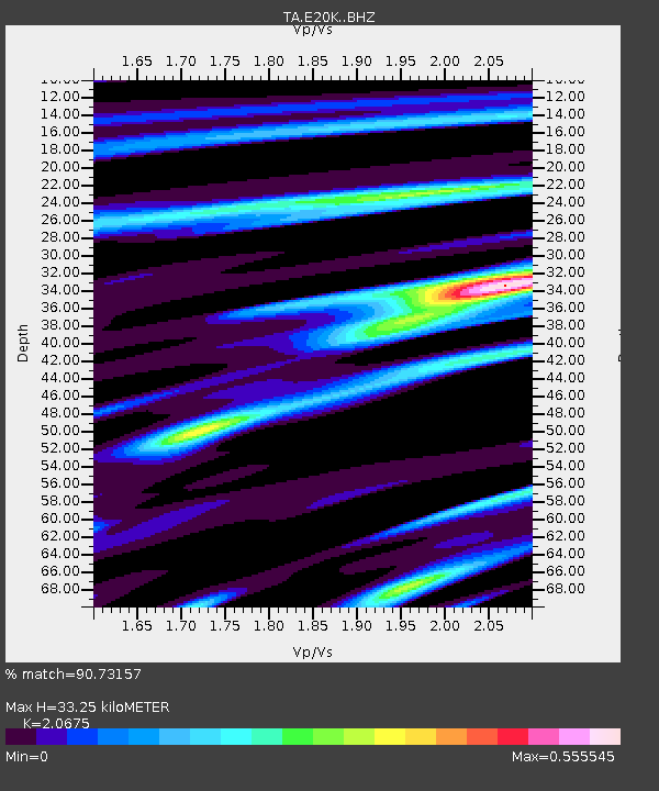
| Estimated Moho Depth: |
33.25 km |
| Estimated Crust Vp/Vs: |
2.07 |
| Assumed Crust Vp: |
6.221 km/s |
| Estimated Crust Vs: |
3.009 km/s |
| Estimated Crust Poisson's Ratio: |
0.35 |
|
| Radial Match: |
90.73157 % |
| Radial Bump: |
400 |
| Transverse Match: |
85.88453 % |
| Transverse Bump: |
400 |
| SOD ConfigId: |
18369291 |
| Insert Time: |
2019-07-03 17:27:54.652 +0000 |
| GWidth: |
2.5 |
| Max Bumps: |
400 |
| Tol: |
0.001 |
|
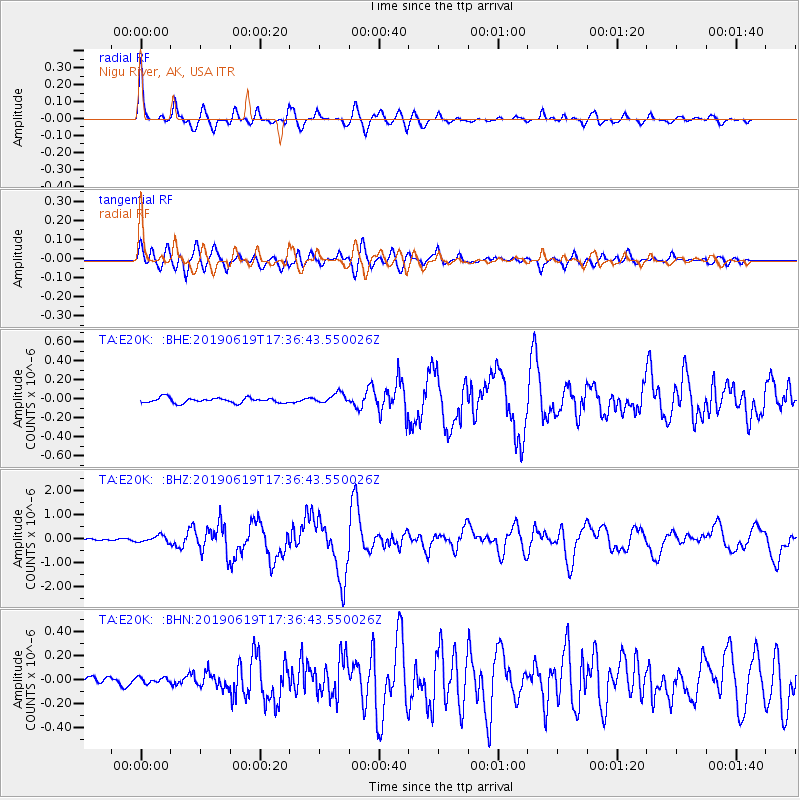
Signal To Noise
| Channel | StoN | STA | LTA |
| TA:E20K: :BHZ:20190619T17:36:43.550026Z | 3.1706183 | 1.3459729E-7 | 4.245143E-8 |
| TA:E20K: :BHN:20190619T17:36:43.550026Z | 0.5535377 | 2.17024E-8 | 3.9206725E-8 |
| TA:E20K: :BHE:20190619T17:36:43.550026Z | 2.0170107 | 5.5183673E-8 | 2.7359137E-8 |
| Arrivals |
| Ps | 5.8 SECOND |
| PpPs | 16 SECOND |
| PsPs/PpSs | 22 SECOND |


