You are here: Home > Network List > US - United States National Seismic Network Stations List
> Station AMTX Amarillo, Texas, USA > Earthquake Result Viewer
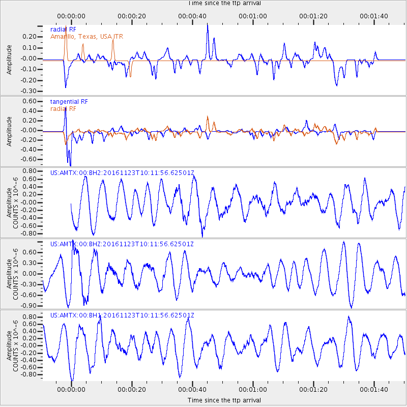
AMTX Amarillo, Texas, USA - Earthquake Result Viewer
*The percent match for this event was below the threshold and hence no stack was calculated.
| Earthquake location: |
Bonin Islands, Japan Region |
| Earthquake latitude/longitude: |
27.2/140.0 |
| Earthquake time(UTC): |
2016/11/23 (328) 09:59:56 GMT |
| Earthquake Depth: |
477 km |
| Earthquake Magnitude: |
5.7 MB |
| Earthquake Catalog/Contributor: |
NEIC PDE/NEIC COMCAT |
|
| Network: |
US United States National Seismic Network |
| Station: |
AMTX Amarillo, Texas, USA |
| Lat/Lon: |
34.53 N/101.41 W |
| Elevation: |
1010 m |
|
| Distance: |
95.5 deg |
| Az: |
46.755 deg |
| Baz: |
308.173 deg |
| Ray Param: |
$rayparam |
*The percent match for this event was below the threshold and hence was not used in the summary stack. |
|
| Radial Match: |
50.78974 % |
| Radial Bump: |
400 |
| Transverse Match: |
80.17761 % |
| Transverse Bump: |
377 |
| SOD ConfigId: |
1858631 |
| Insert Time: |
2016-12-07 10:02:32.266 +0000 |
| GWidth: |
2.5 |
| Max Bumps: |
400 |
| Tol: |
0.001 |
|
Signal To Noise
| Channel | StoN | STA | LTA |
| US:AMTX:00:BHZ:20161123T10:11:56.62501Z | 1.5143138 | 6.4841123E-7 | 4.2818817E-7 |
| US:AMTX:00:BH1:20161123T10:11:56.62501Z | 2.5966012 | 5.563351E-7 | 2.1425514E-7 |
| US:AMTX:00:BH2:20161123T10:11:56.62501Z | 0.55017036 | 2.1924254E-7 | 3.9849934E-7 |
| Arrivals |
| Ps | |
| PpPs | |
| PsPs/PpSs | |


