You are here: Home > Network List > TA - USArray Transportable Network (new EarthScope stations) Stations List
> Station B21A Ellsworth Farm, Hinsdale, MT, USA > Earthquake Result Viewer
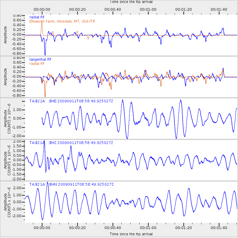
B21A Ellsworth Farm, Hinsdale, MT, USA - Earthquake Result Viewer
*The percent match for this event was below the threshold and hence no stack was calculated.
| Earthquake location: |
Kuril Islands |
| Earthquake latitude/longitude: |
48.3/154.2 |
| Earthquake time(UTC): |
2009/09/11 (254) 08:49:11 GMT |
| Earthquake Depth: |
35 km |
| Earthquake Magnitude: |
5.8 MB, 5.0 MS, 5.6 MW, 5.6 MW |
| Earthquake Catalog/Contributor: |
WHDF/NEIC |
|
| Network: |
TA USArray Transportable Network (new EarthScope stations) |
| Station: |
B21A Ellsworth Farm, Hinsdale, MT, USA |
| Lat/Lon: |
48.43 N/107.02 W |
| Elevation: |
661 m |
|
| Distance: |
60.8 deg |
| Az: |
48.935 deg |
| Baz: |
310.893 deg |
| Ray Param: |
$rayparam |
*The percent match for this event was below the threshold and hence was not used in the summary stack. |
|
| Radial Match: |
59.057266 % |
| Radial Bump: |
277 |
| Transverse Match: |
33.08988 % |
| Transverse Bump: |
264 |
| SOD ConfigId: |
2622 |
| Insert Time: |
2010-03-07 00:11:26.401 +0000 |
| GWidth: |
2.5 |
| Max Bumps: |
400 |
| Tol: |
0.001 |
|
Signal To Noise
| Channel | StoN | STA | LTA |
| TA:B21A: :BHZ:20090911T08:58:49.925027Z | 2.691446 | 8.5916406E-7 | 3.1922025E-7 |
| TA:B21A: :BHN:20090911T08:58:49.925027Z | 1.9587944 | 1.7212743E-6 | 8.787417E-7 |
| TA:B21A: :BHE:20090911T08:58:49.925027Z | 0.6704334 | 4.3941282E-7 | 6.5541604E-7 |
| Arrivals |
| Ps | |
| PpPs | |
| PsPs/PpSs | |


