You are here: Home > Network List > TA - USArray Transportable Network (new EarthScope stations) Stations List
> Station B21A Ellsworth Farm, Hinsdale, MT, USA > Earthquake Result Viewer
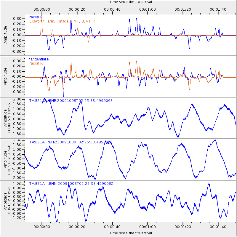
B21A Ellsworth Farm, Hinsdale, MT, USA - Earthquake Result Viewer
*The percent match for this event was below the threshold and hence no stack was calculated.
| Earthquake location: |
Santa Cruz Islands |
| Earthquake latitude/longitude: |
-11.7/166.2 |
| Earthquake time(UTC): |
2009/10/08 (281) 02:12:39 GMT |
| Earthquake Depth: |
35 km |
| Earthquake Magnitude: |
5.8 MB, 6.6 MW |
| Earthquake Catalog/Contributor: |
WHDF/NEIC |
|
| Network: |
TA USArray Transportable Network (new EarthScope stations) |
| Station: |
B21A Ellsworth Farm, Hinsdale, MT, USA |
| Lat/Lon: |
48.43 N/107.02 W |
| Elevation: |
661 m |
|
| Distance: |
96.5 deg |
| Az: |
42.016 deg |
| Baz: |
259.887 deg |
| Ray Param: |
$rayparam |
*The percent match for this event was below the threshold and hence was not used in the summary stack. |
|
| Radial Match: |
57.896744 % |
| Radial Bump: |
400 |
| Transverse Match: |
66.606895 % |
| Transverse Bump: |
400 |
| SOD ConfigId: |
2622 |
| Insert Time: |
2010-03-07 00:11:33.446 +0000 |
| GWidth: |
2.5 |
| Max Bumps: |
400 |
| Tol: |
0.001 |
|
Signal To Noise
| Channel | StoN | STA | LTA |
| TA:B21A: :BHZ:20091008T02:25:33.499006Z | 1.2432616 | 8.529311E-7 | 6.8604317E-7 |
| TA:B21A: :BHN:20091008T02:25:33.499006Z | 1.2968245 | 5.860825E-7 | 4.5193661E-7 |
| TA:B21A: :BHE:20091008T02:25:33.499006Z | 1.0525335 | 1.2480191E-6 | 1.1857286E-6 |
| Arrivals |
| Ps | |
| PpPs | |
| PsPs/PpSs | |


