You are here: Home > Network List > TA - USArray Transportable Network (new EarthScope stations) Stations List
> Station B21A Ellsworth Farm, Hinsdale, MT, USA > Earthquake Result Viewer
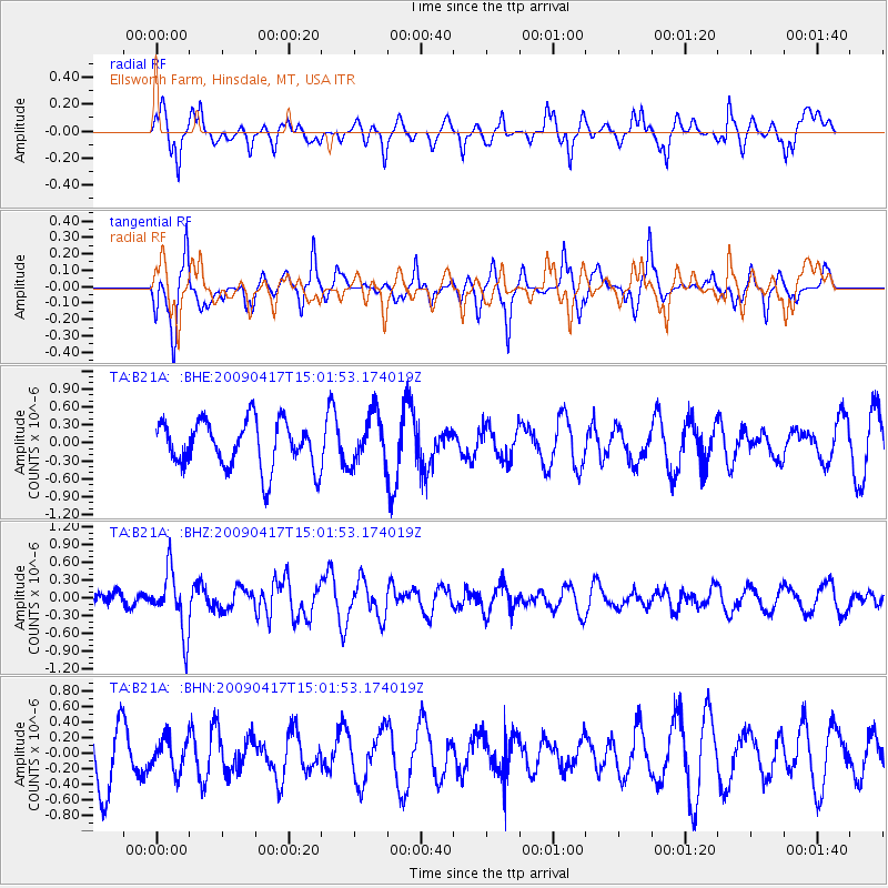
B21A Ellsworth Farm, Hinsdale, MT, USA - Earthquake Result Viewer
*The percent match for this event was below the threshold and hence no stack was calculated.
| Earthquake location: |
Kuril Islands |
| Earthquake latitude/longitude: |
46.2/151.7 |
| Earthquake time(UTC): |
2009/04/17 (107) 14:51:58 GMT |
| Earthquake Depth: |
49 km |
| Earthquake Magnitude: |
5.5 MB, 5.0 MS, 5.7 MW, 5.6 MW |
| Earthquake Catalog/Contributor: |
WHDF/NEIC |
|
| Network: |
TA USArray Transportable Network (new EarthScope stations) |
| Station: |
B21A Ellsworth Farm, Hinsdale, MT, USA |
| Lat/Lon: |
48.43 N/107.02 W |
| Elevation: |
661 m |
|
| Distance: |
63.5 deg |
| Az: |
46.862 deg |
| Baz: |
310.414 deg |
| Ray Param: |
$rayparam |
*The percent match for this event was below the threshold and hence was not used in the summary stack. |
|
| Radial Match: |
58.40005 % |
| Radial Bump: |
333 |
| Transverse Match: |
56.325302 % |
| Transverse Bump: |
327 |
| SOD ConfigId: |
2658 |
| Insert Time: |
2010-03-07 00:11:40.542 +0000 |
| GWidth: |
2.5 |
| Max Bumps: |
400 |
| Tol: |
0.001 |
|
Signal To Noise
| Channel | StoN | STA | LTA |
| TA:B21A: :BHZ:20090417T15:01:53.174019Z | 2.6938276 | 5.181698E-7 | 1.9235449E-7 |
| TA:B21A: :BHN:20090417T15:01:53.174019Z | 0.5470347 | 2.097176E-7 | 3.8337166E-7 |
| TA:B21A: :BHE:20090417T15:01:53.174019Z | 1.0762309 | 4.2230664E-7 | 3.923941E-7 |
| Arrivals |
| Ps | |
| PpPs | |
| PsPs/PpSs | |


