You are here: Home > Network List > TA - USArray Transportable Network (new EarthScope stations) Stations List
> Station B21A Ellsworth Farm, Hinsdale, MT, USA > Earthquake Result Viewer
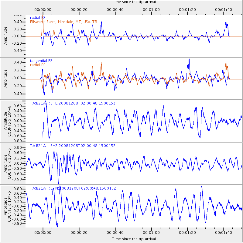
B21A Ellsworth Farm, Hinsdale, MT, USA - Earthquake Result Viewer
*The percent match for this event was below the threshold and hence no stack was calculated.
| Earthquake location: |
Northern Mid-Atlantic Ridge |
| Earthquake latitude/longitude: |
13.4/-44.8 |
| Earthquake time(UTC): |
2008/12/08 (343) 01:51:01 GMT |
| Earthquake Depth: |
10 km |
| Earthquake Magnitude: |
5.6 MB, 5.1 MS, 5.5 MW, 5.5 MW |
| Earthquake Catalog/Contributor: |
WHDF/NEIC |
|
| Network: |
TA USArray Transportable Network (new EarthScope stations) |
| Station: |
B21A Ellsworth Farm, Hinsdale, MT, USA |
| Lat/Lon: |
48.43 N/107.02 W |
| Elevation: |
661 m |
|
| Distance: |
61.7 deg |
| Az: |
317.99 deg |
| Baz: |
102.11 deg |
| Ray Param: |
$rayparam |
*The percent match for this event was below the threshold and hence was not used in the summary stack. |
|
| Radial Match: |
49.66999 % |
| Radial Bump: |
314 |
| Transverse Match: |
65.85444 % |
| Transverse Bump: |
386 |
| SOD ConfigId: |
2658 |
| Insert Time: |
2010-03-07 00:11:52.728 +0000 |
| GWidth: |
2.5 |
| Max Bumps: |
400 |
| Tol: |
0.001 |
|
Signal To Noise
| Channel | StoN | STA | LTA |
| TA:B21A: :BHZ:20081208T02:00:48.150015Z | 3.857858 | 4.6654412E-7 | 1.2093346E-7 |
| TA:B21A: :BHN:20081208T02:00:48.150015Z | 1.015571 | 3.6700752E-7 | 3.6138044E-7 |
| TA:B21A: :BHE:20081208T02:00:48.150015Z | 0.84949905 | 2.3813789E-7 | 2.8032744E-7 |
| Arrivals |
| Ps | |
| PpPs | |
| PsPs/PpSs | |


