You are here: Home > Network List > TS - TERRAscope (Southern California Seismic Network) Stations List
> Station GSC Goldston, California, USA > Earthquake Result Viewer
GSC Goldston, California, USA - Earthquake Result Viewer
| Earthquake location: |
Northern Peru |
| Earthquake latitude/longitude: |
-3.9/-77.0 |
| Earthquake time(UTC): |
1995/05/02 (122) 06:06:05 GMT |
| Earthquake Depth: |
103 km |
| Earthquake Magnitude: |
6.5 MB, 6.7 UNKNOWN, 6.6 MW |
| Earthquake Catalog/Contributor: |
WHDF/NEIC |
|
| Network: |
TS TERRAscope (Southern California Seismic Network) |
| Station: |
GSC Goldston, California, USA |
| Lat/Lon: |
35.30 N/116.81 W |
| Elevation: |
990 m |
|
| Distance: |
54.0 deg |
| Az: |
319.605 deg |
| Baz: |
127.765 deg |
| Ray Param: |
0.06543109 |
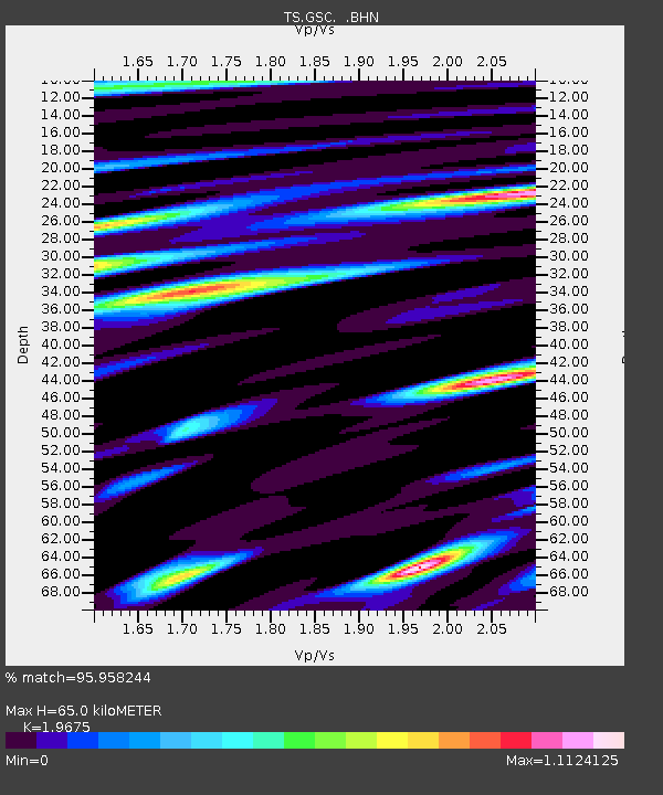
| Estimated Moho Depth: |
65.0 km |
| Estimated Crust Vp/Vs: |
1.97 |
| Assumed Crust Vp: |
6.276 km/s |
| Estimated Crust Vs: |
3.19 km/s |
| Estimated Crust Poisson's Ratio: |
0.33 |
|
| Radial Match: |
95.958244 % |
| Radial Bump: |
381 |
| Transverse Match: |
87.47427 % |
| Transverse Bump: |
400 |
| SOD ConfigId: |
6273 |
| Insert Time: |
2010-02-26 14:17:26.619 +0000 |
| GWidth: |
2.5 |
| Max Bumps: |
400 |
| Tol: |
0.001 |
|

Signal To Noise
| Channel | StoN | STA | LTA |
| TS:GSC: :BHN:19950502T06:14:48.590002Z | 3.563863 | 4.1419275E-7 | 1.16220164E-7 |
| TS:GSC: :BHE:19950502T06:14:48.590002Z | 3.9971375 | 6.05431E-7 | 1.5146615E-7 |
| TS:GSC: :BHZ:19950502T06:14:48.590002Z | 14.145549 | 2.1011042E-6 | 1.4853465E-7 |
| Arrivals |
| Ps | 10 SECOND |
| PpPs | 29 SECOND |
| PsPs/PpSs | 40 SECOND |


