You are here: Home > Network List > UU - University of Utah Regional Network Stations List
> Station KNB Kanab, UT, USA > Earthquake Result Viewer
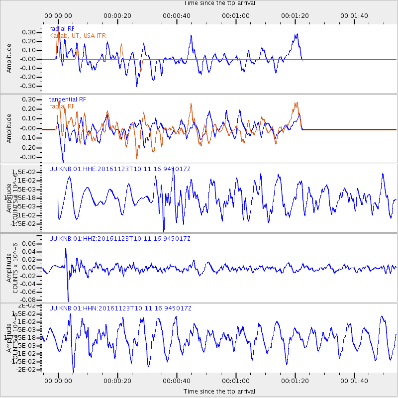
KNB Kanab, UT, USA - Earthquake Result Viewer
*The percent match for this event was below the threshold and hence no stack was calculated.
| Earthquake location: |
Bonin Islands, Japan Region |
| Earthquake latitude/longitude: |
27.2/140.0 |
| Earthquake time(UTC): |
2016/11/23 (328) 09:59:56 GMT |
| Earthquake Depth: |
477 km |
| Earthquake Magnitude: |
5.7 MB |
| Earthquake Catalog/Contributor: |
NEIC PDE/NEIC COMCAT |
|
| Network: |
UU University of Utah Regional Network |
| Station: |
KNB Kanab, UT, USA |
| Lat/Lon: |
37.02 N/112.82 W |
| Elevation: |
1715 m |
|
| Distance: |
86.5 deg |
| Az: |
50.02 deg |
| Baz: |
301.459 deg |
| Ray Param: |
$rayparam |
*The percent match for this event was below the threshold and hence was not used in the summary stack. |
|
| Radial Match: |
56.014397 % |
| Radial Bump: |
382 |
| Transverse Match: |
50.526596 % |
| Transverse Bump: |
389 |
| SOD ConfigId: |
1858631 |
| Insert Time: |
2016-12-07 10:03:19.274 +0000 |
| GWidth: |
2.5 |
| Max Bumps: |
400 |
| Tol: |
0.001 |
|
Signal To Noise
| Channel | StoN | STA | LTA |
| UU:KNB:01:HHZ:20161123T10:11:16.945017Z | 5.7299147 | 2.492067E-8 | 4.349222E-9 |
| UU:KNB:01:HHN:20161123T10:11:16.945017Z | 1.1965258 | 6.6735253E-9 | 5.5774185E-9 |
| UU:KNB:01:HHE:20161123T10:11:16.945017Z | 0.81595874 | 4.906764E-9 | 6.013495E-9 |
| Arrivals |
| Ps | |
| PpPs | |
| PsPs/PpSs | |


