You are here: Home > Network List > TA - USArray Transportable Network (new EarthScope stations) Stations List
> Station F17K Baldwin Penninsula, AK, USA > Earthquake Result Viewer
F17K Baldwin Penninsula, AK, USA - Earthquake Result Viewer
| Earthquake location: |
Santa Cruz Islands |
| Earthquake latitude/longitude: |
-12.7/166.3 |
| Earthquake time(UTC): |
2019/06/19 (170) 23:14:59 GMT |
| Earthquake Depth: |
10 km |
| Earthquake Magnitude: |
5.7 Mww |
| Earthquake Catalog/Contributor: |
NEIC PDE/us |
|
| Network: |
TA USArray Transportable Network (new EarthScope stations) |
| Station: |
F17K Baldwin Penninsula, AK, USA |
| Lat/Lon: |
66.44 N/161.25 W |
| Elevation: |
51 m |
|
| Distance: |
82.4 deg |
| Az: |
12.578 deg |
| Baz: |
211.925 deg |
| Ray Param: |
0.046886258 |
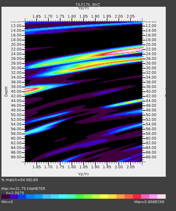
| Estimated Moho Depth: |
21.75 km |
| Estimated Crust Vp/Vs: |
2.09 |
| Assumed Crust Vp: |
6.276 km/s |
| Estimated Crust Vs: |
3.006 km/s |
| Estimated Crust Poisson's Ratio: |
0.35 |
|
| Radial Match: |
84.86165 % |
| Radial Bump: |
400 |
| Transverse Match: |
65.64978 % |
| Transverse Bump: |
400 |
| SOD ConfigId: |
18369291 |
| Insert Time: |
2019-07-03 23:19:54.053 +0000 |
| GWidth: |
2.5 |
| Max Bumps: |
400 |
| Tol: |
0.001 |
|

Signal To Noise
| Channel | StoN | STA | LTA |
| TA:F17K: :BHZ:20190619T23:26:50.824984Z | 7.5414853 | 3.9489507E-7 | 5.2363035E-8 |
| TA:F17K: :BHN:20190619T23:26:50.824984Z | 3.270085 | 1.7219064E-7 | 5.2656315E-8 |
| TA:F17K: :BHE:20190619T23:26:50.824984Z | 1.3647572 | 4.656257E-8 | 3.4117843E-8 |
| Arrivals |
| Ps | 3.9 SECOND |
| PpPs | 10 SECOND |
| PsPs/PpSs | 14 SECOND |


