You are here: Home > Network List > TA - USArray Transportable Network (new EarthScope stations) Stations List
> Station G21K Allakaket, AK, USA > Earthquake Result Viewer
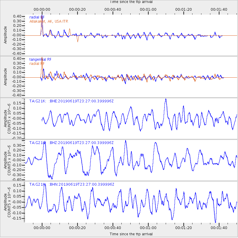
G21K Allakaket, AK, USA - Earthquake Result Viewer
*The percent match for this event was below the threshold and hence no stack was calculated.
| Earthquake location: |
Santa Cruz Islands |
| Earthquake latitude/longitude: |
-12.7/166.3 |
| Earthquake time(UTC): |
2019/06/19 (170) 23:14:59 GMT |
| Earthquake Depth: |
10 km |
| Earthquake Magnitude: |
5.7 Mww |
| Earthquake Catalog/Contributor: |
NEIC PDE/us |
|
| Network: |
TA USArray Transportable Network (new EarthScope stations) |
| Station: |
G21K Allakaket, AK, USA |
| Lat/Lon: |
66.52 N/153.51 W |
| Elevation: |
446 m |
|
| Distance: |
84.3 deg |
| Az: |
15.077 deg |
| Baz: |
219.308 deg |
| Ray Param: |
$rayparam |
*The percent match for this event was below the threshold and hence was not used in the summary stack. |
|
| Radial Match: |
61.230206 % |
| Radial Bump: |
400 |
| Transverse Match: |
66.51896 % |
| Transverse Bump: |
400 |
| SOD ConfigId: |
18369291 |
| Insert Time: |
2019-07-03 23:20:04.057 +0000 |
| GWidth: |
2.5 |
| Max Bumps: |
400 |
| Tol: |
0.001 |
|
Signal To Noise
| Channel | StoN | STA | LTA |
| TA:G21K: :BHZ:20190619T23:27:00.399996Z | 5.425129 | 2.48928E-7 | 4.5884256E-8 |
| TA:G21K: :BHN:20190619T23:27:00.399996Z | 1.7939888 | 9.1842544E-8 | 5.1194604E-8 |
| TA:G21K: :BHE:20190619T23:27:00.399996Z | 1.6994917 | 6.520961E-8 | 3.8370068E-8 |
| Arrivals |
| Ps | |
| PpPs | |
| PsPs/PpSs | |


