You are here: Home > Network List > TA - USArray Transportable Network (new EarthScope stations) Stations List
> Station H17K Granite Mountain, AK, USA > Earthquake Result Viewer
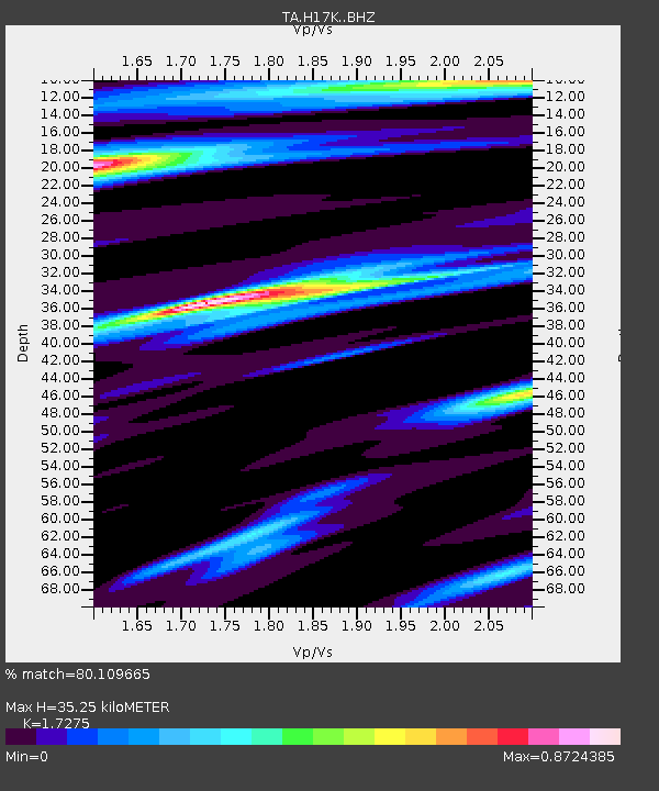
H17K Granite Mountain, AK, USA - Earthquake Result Viewer
| Earthquake location: |
Santa Cruz Islands |
| Earthquake latitude/longitude: |
-12.7/166.3 |
| Earthquake time(UTC): |
2019/06/19 (170) 23:14:59 GMT |
| Earthquake Depth: |
10 km |
| Earthquake Magnitude: |
5.7 Mww |
| Earthquake Catalog/Contributor: |
NEIC PDE/us |
|
| Network: |
TA USArray Transportable Network (new EarthScope stations) |
| Station: |
H17K Granite Mountain, AK, USA |
| Lat/Lon: |
64.94 N/159.91 W |
| Elevation: |
396 m |
|
| Distance: |
81.5 deg |
| Az: |
13.872 deg |
| Baz: |
213.324 deg |
| Ray Param: |
0.047567744 |
| Estimated Moho Depth: |
35.25 km |
| Estimated Crust Vp/Vs: |
1.73 |
| Assumed Crust Vp: |
6.1 km/s |
| Estimated Crust Vs: |
3.531 km/s |
| Estimated Crust Poisson's Ratio: |
0.25 |
|
| Radial Match: |
80.109665 % |
| Radial Bump: |
400 |
| Transverse Match: |
62.92023 % |
| Transverse Bump: |
400 |
| SOD ConfigId: |
18369291 |
| Insert Time: |
2019-07-03 23:20:13.217 +0000 |
| GWidth: |
2.5 |
| Max Bumps: |
400 |
| Tol: |
0.001 |
|

Signal To Noise
| Channel | StoN | STA | LTA |
| TA:H17K: :BHZ:20190619T23:26:45.699984Z | 6.8365364 | 2.8185903E-7 | 4.1228336E-8 |
| TA:H17K: :BHN:20190619T23:26:45.699984Z | 3.166614 | 1.0350607E-7 | 3.2686668E-8 |
| TA:H17K: :BHE:20190619T23:26:45.699984Z | 1.5398356 | 4.8896684E-8 | 3.175448E-8 |
| Arrivals |
| Ps | 4.3 SECOND |
| PpPs | 15 SECOND |
| PsPs/PpSs | 20 SECOND |


