You are here: Home > Network List > TA - USArray Transportable Network (new EarthScope stations) Stations List
> Station I17K Unalakleet, AK, USA > Earthquake Result Viewer
I17K Unalakleet, AK, USA - Earthquake Result Viewer

| Earthquake location: |
Santa Cruz Islands |
| Earthquake latitude/longitude: |
-12.7/166.3 |
| Earthquake time(UTC): |
2019/06/19 (170) 23:14:59 GMT |
| Earthquake Depth: |
10 km |
| Earthquake Magnitude: |
5.7 Mww |
| Earthquake Catalog/Contributor: |
NEIC PDE/us |
|
| Network: |
TA USArray Transportable Network (new EarthScope stations) |
| Station: |
I17K Unalakleet, AK, USA |
| Lat/Lon: |
63.89 N/160.70 W |
| Elevation: |
105 m |
|
| Distance: |
80.4 deg |
| Az: |
14.165 deg |
| Baz: |
212.665 deg |
| Ray Param: |
0.04830579 |
| Estimated Moho Depth: |
32.0 km |
| Estimated Crust Vp/Vs: |
1.83 |
| Assumed Crust Vp: |
6.276 km/s |
| Estimated Crust Vs: |
3.425 km/s |
| Estimated Crust Poisson's Ratio: |
0.29 |
|
| Radial Match: |
81.04154 % |
| Radial Bump: |
400 |
| Transverse Match: |
64.85153 % |
| Transverse Bump: |
400 |
| SOD ConfigId: |
18369291 |
| Insert Time: |
2019-07-03 23:20:19.851 +0000 |
| GWidth: |
2.5 |
| Max Bumps: |
400 |
| Tol: |
0.001 |
|
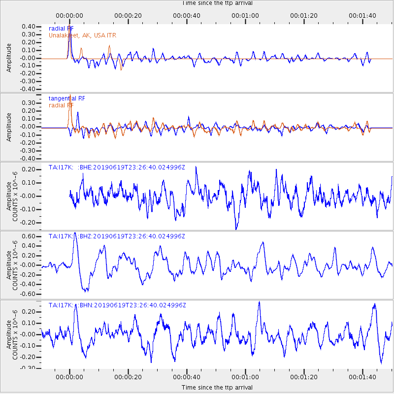
Signal To Noise
| Channel | StoN | STA | LTA |
| TA:I17K: :BHZ:20190619T23:26:40.024996Z | 6.7383547 | 3.5530496E-7 | 5.2728744E-8 |
| TA:I17K: :BHN:20190619T23:26:40.024996Z | 2.3585584 | 1.290283E-7 | 5.4706426E-8 |
| TA:I17K: :BHE:20190619T23:26:40.024996Z | 1.2166125 | 5.903244E-8 | 4.8521976E-8 |
| Arrivals |
| Ps | 4.4 SECOND |
| PpPs | 14 SECOND |
| PsPs/PpSs | 18 SECOND |


