You are here: Home > Network List > TA - USArray Transportable Network (new EarthScope stations) Stations List
> Station B21A Ellsworth Farm, Hinsdale, MT, USA > Earthquake Result Viewer
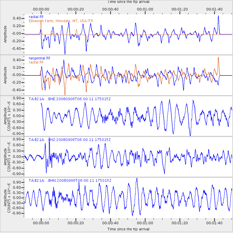
B21A Ellsworth Farm, Hinsdale, MT, USA - Earthquake Result Viewer
*The percent match for this event was below the threshold and hence no stack was calculated.
| Earthquake location: |
Hindu Kush Region, Afghanistan |
| Earthquake latitude/longitude: |
36.5/70.9 |
| Earthquake time(UTC): |
2008/09/06 (250) 05:47:39 GMT |
| Earthquake Depth: |
192 km |
| Earthquake Magnitude: |
5.5 MB, 5.8 MW, 5.8 MW |
| Earthquake Catalog/Contributor: |
WHDF/NEIC |
|
| Network: |
TA USArray Transportable Network (new EarthScope stations) |
| Station: |
B21A Ellsworth Farm, Hinsdale, MT, USA |
| Lat/Lon: |
48.43 N/107.02 W |
| Elevation: |
661 m |
|
| Distance: |
95.4 deg |
| Az: |
358.629 deg |
| Baz: |
1.659 deg |
| Ray Param: |
$rayparam |
*The percent match for this event was below the threshold and hence was not used in the summary stack. |
|
| Radial Match: |
63.212997 % |
| Radial Bump: |
400 |
| Transverse Match: |
63.12703 % |
| Transverse Bump: |
400 |
| SOD ConfigId: |
2560 |
| Insert Time: |
2010-03-07 00:12:25.245 +0000 |
| GWidth: |
2.5 |
| Max Bumps: |
400 |
| Tol: |
0.001 |
|
Signal To Noise
| Channel | StoN | STA | LTA |
| TA:B21A: :BHZ:20080906T06:00:11.175015Z | 4.323803 | 3.6101028E-7 | 8.349369E-8 |
| TA:B21A: :BHN:20080906T06:00:11.175015Z | 1.5334564 | 3.7860974E-7 | 2.4689956E-7 |
| TA:B21A: :BHE:20080906T06:00:11.175015Z | 0.9298709 | 2.6996017E-7 | 2.9032003E-7 |
| Arrivals |
| Ps | |
| PpPs | |
| PsPs/PpSs | |


