You are here: Home > Network List > TA - USArray Transportable Network (new EarthScope stations) Stations List
> Station C22A Vida, MT, USA > Earthquake Result Viewer
C22A Vida, MT, USA - Earthquake Result Viewer
| Earthquake location: |
Virgin Islands |
| Earthquake latitude/longitude: |
19.2/-64.8 |
| Earthquake time(UTC): |
2008/10/11 (285) 10:40:14 GMT |
| Earthquake Depth: |
23 km |
| Earthquake Magnitude: |
6.1 MB, 5.9 MS, 6.1 MW, 6.0 MW |
| Earthquake Catalog/Contributor: |
WHDF/NEIC |
|
| Network: |
TA USArray Transportable Network (new EarthScope stations) |
| Station: |
C22A Vida, MT, USA |
| Lat/Lon: |
47.75 N/105.88 W |
| Elevation: |
745 m |
|
| Distance: |
43.8 deg |
| Az: |
320.174 deg |
| Baz: |
116.227 deg |
| Ray Param: |
0.07228533 |
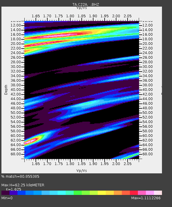
| Estimated Moho Depth: |
62.25 km |
| Estimated Crust Vp/Vs: |
1.62 |
| Assumed Crust Vp: |
6.438 km/s |
| Estimated Crust Vs: |
3.962 km/s |
| Estimated Crust Poisson's Ratio: |
0.20 |
|
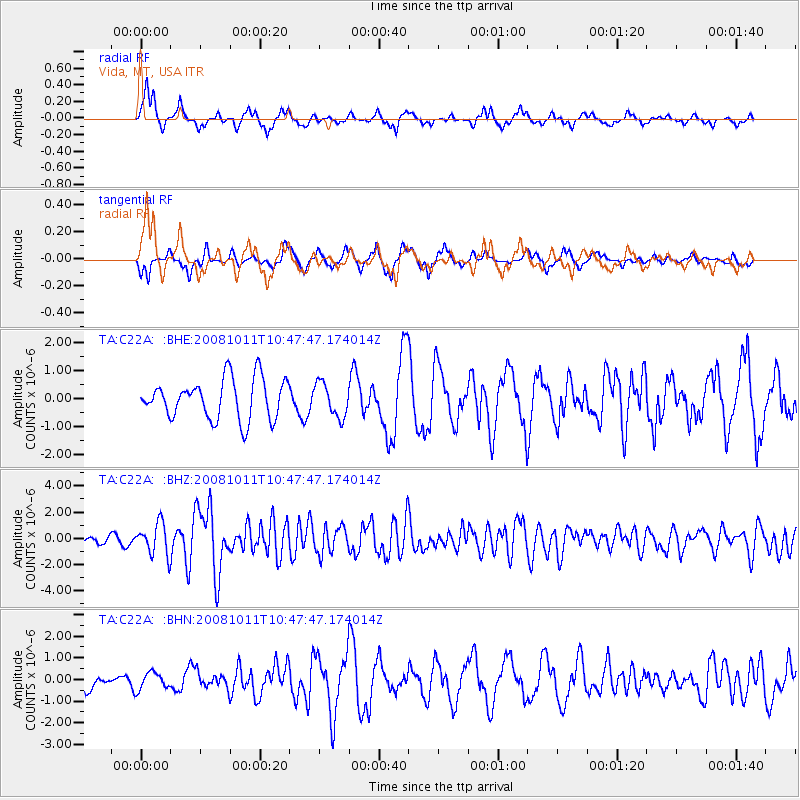
| Radial Match: |
80.855385 % |
| Radial Bump: |
368 |
| Transverse Match: |
53.812904 % |
| Transverse Bump: |
280 |
| SOD ConfigId: |
2556 |
| Insert Time: |
2010-03-07 00:12:40.512 +0000 |
| GWidth: |
2.5 |
| Max Bumps: |
400 |
| Tol: |
0.001 |
|
Signal To Noise
| Channel | StoN | STA | LTA |
| TA:C22A: :BHZ:20081011T10:47:47.174014Z | 5.37008 | 1.1982693E-6 | 2.2313806E-7 |
| TA:C22A: :BHN:20081011T10:47:47.174014Z | 0.7108472 | 3.9064057E-7 | 5.495422E-7 |
| TA:C22A: :BHE:20081011T10:47:47.174014Z | 0.8469726 | 6.065597E-7 | 7.161503E-7 |
| Arrivals |
| Ps | 6.5 SECOND |
| PpPs | 24 SECOND |
| PsPs/PpSs | 30 SECOND |


