You are here: Home > Network List > TA - USArray Transportable Network (new EarthScope stations) Stations List
> Station C22A Vida, MT, USA > Earthquake Result Viewer
C22A Vida, MT, USA - Earthquake Result Viewer
| Earthquake location: |
Central Mid-Atlantic Ridge |
| Earthquake latitude/longitude: |
8.1/-38.7 |
| Earthquake time(UTC): |
2008/09/10 (254) 13:08:14 GMT |
| Earthquake Depth: |
10 km |
| Earthquake Magnitude: |
6.3 MB, 6.5 MS, 6.6 MW, 6.6 MW |
| Earthquake Catalog/Contributor: |
WHDF/NEIC |
|
| Network: |
TA USArray Transportable Network (new EarthScope stations) |
| Station: |
C22A Vida, MT, USA |
| Lat/Lon: |
47.75 N/105.88 W |
| Elevation: |
745 m |
|
| Distance: |
68.7 deg |
| Az: |
318.133 deg |
| Baz: |
101.711 deg |
| Ray Param: |
0.056102857 |
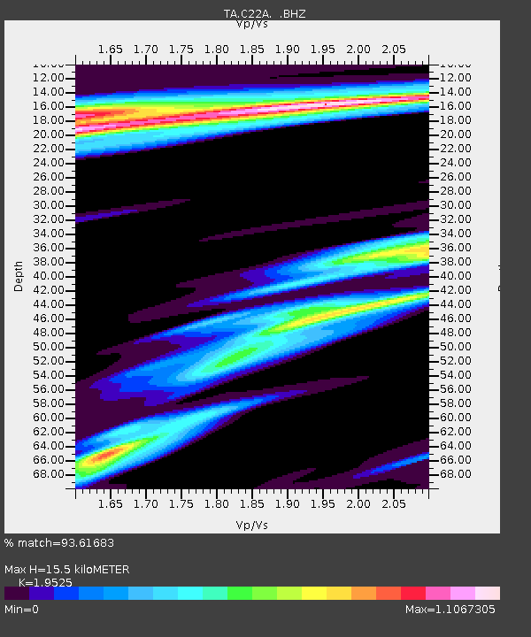
| Estimated Moho Depth: |
15.5 km |
| Estimated Crust Vp/Vs: |
1.95 |
| Assumed Crust Vp: |
6.438 km/s |
| Estimated Crust Vs: |
3.297 km/s |
| Estimated Crust Poisson's Ratio: |
0.32 |
|
| Radial Match: |
93.61683 % |
| Radial Bump: |
383 |
| Transverse Match: |
86.94982 % |
| Transverse Bump: |
400 |
| SOD ConfigId: |
2560 |
| Insert Time: |
2010-03-07 00:12:48.474 +0000 |
| GWidth: |
2.5 |
| Max Bumps: |
400 |
| Tol: |
0.001 |
|
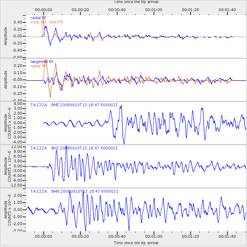
Signal To Noise
| Channel | StoN | STA | LTA |
| TA:C22A: :BHZ:20080910T13:18:47.600002Z | 5.30588 | 8.3462044E-7 | 1.5730103E-7 |
| TA:C22A: :BHN:20080910T13:18:47.600002Z | 0.78517115 | 2.1429545E-7 | 2.7292833E-7 |
| TA:C22A: :BHE:20080910T13:18:47.600002Z | 1.2384928 | 4.0683122E-7 | 3.2848897E-7 |
| Arrivals |
| Ps | 2.4 SECOND |
| PpPs | 6.9 SECOND |
| PsPs/PpSs | 9.2 SECOND |


