You are here: Home > Network List > TA - USArray Transportable Network (new EarthScope stations) Stations List
> Station C22A Vida, MT, USA > Earthquake Result Viewer
C22A Vida, MT, USA - Earthquake Result Viewer
| Earthquake location: |
Hindu Kush Region, Afghanistan |
| Earthquake latitude/longitude: |
36.4/70.7 |
| Earthquake time(UTC): |
2009/01/03 (003) 20:23:20 GMT |
| Earthquake Depth: |
205 km |
| Earthquake Magnitude: |
5.8 MB |
| Earthquake Catalog/Contributor: |
WHDF/NEIC |
|
| Network: |
TA USArray Transportable Network (new EarthScope stations) |
| Station: |
C22A Vida, MT, USA |
| Lat/Lon: |
47.75 N/105.88 W |
| Elevation: |
745 m |
|
| Distance: |
96.2 deg |
| Az: |
357.711 deg |
| Baz: |
2.736 deg |
| Ray Param: |
0.040416688 |
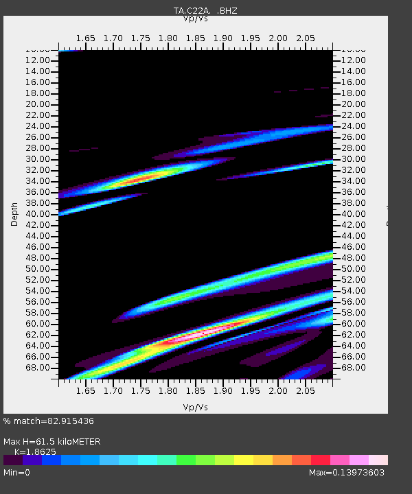
| Estimated Moho Depth: |
61.5 km |
| Estimated Crust Vp/Vs: |
1.86 |
| Assumed Crust Vp: |
6.438 km/s |
| Estimated Crust Vs: |
3.456 km/s |
| Estimated Crust Poisson's Ratio: |
0.30 |
|
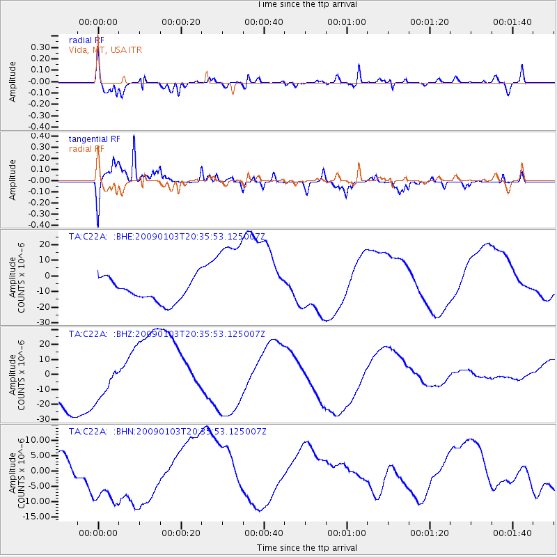
| Radial Match: |
82.915436 % |
| Radial Bump: |
372 |
| Transverse Match: |
93.37315 % |
| Transverse Bump: |
304 |
| SOD ConfigId: |
2834 |
| Insert Time: |
2010-03-07 00:12:51.802 +0000 |
| GWidth: |
2.5 |
| Max Bumps: |
400 |
| Tol: |
0.001 |
|
Signal To Noise
| Channel | StoN | STA | LTA |
| TA:C22A: :BHZ:20090103T20:35:53.125007Z | 0.6448391 | 1.3107851E-5 | 2.0327321E-5 |
| TA:C22A: :BHN:20090103T20:35:53.125007Z | 2.3787024 | 1.2761995E-5 | 5.365108E-6 |
| TA:C22A: :BHE:20090103T20:35:53.125007Z | 3.885914 | 2.7858969E-5 | 7.1692193E-6 |
| Arrivals |
| Ps | 8.4 SECOND |
| PpPs | 27 SECOND |
| PsPs/PpSs | 35 SECOND |


