You are here: Home > Network List > TA - USArray Transportable Network (new EarthScope stations) Stations List
> Station C22A Vida, MT, USA > Earthquake Result Viewer
C22A Vida, MT, USA - Earthquake Result Viewer
| Earthquake location: |
Azores Islands Region |
| Earthquake latitude/longitude: |
36.2/-33.9 |
| Earthquake time(UTC): |
2009/11/04 (308) 18:41:44 GMT |
| Earthquake Depth: |
10 km |
| Earthquake Magnitude: |
5.7 MB, 5.6 MS, 5.9 MW, 5.8 MW |
| Earthquake Catalog/Contributor: |
WHDF/NEIC |
|
| Network: |
TA USArray Transportable Network (new EarthScope stations) |
| Station: |
C22A Vida, MT, USA |
| Lat/Lon: |
47.75 N/105.88 W |
| Elevation: |
745 m |
|
| Distance: |
53.0 deg |
| Az: |
306.488 deg |
| Baz: |
74.604 deg |
| Ray Param: |
0.06640866 |
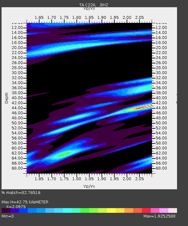
| Estimated Moho Depth: |
42.75 km |
| Estimated Crust Vp/Vs: |
2.10 |
| Assumed Crust Vp: |
6.438 km/s |
| Estimated Crust Vs: |
3.069 km/s |
| Estimated Crust Poisson's Ratio: |
0.35 |
|
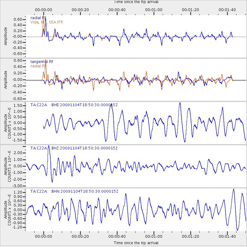
| Radial Match: |
82.76516 % |
| Radial Bump: |
354 |
| Transverse Match: |
70.19541 % |
| Transverse Bump: |
357 |
| SOD ConfigId: |
2622 |
| Insert Time: |
2010-03-07 00:13:06.828 +0000 |
| GWidth: |
2.5 |
| Max Bumps: |
400 |
| Tol: |
0.001 |
|
Signal To Noise
| Channel | StoN | STA | LTA |
| TA:C22A: :BHZ:20091104T18:50:30.000015Z | 7.4369774 | 1.5544126E-6 | 2.0901135E-7 |
| TA:C22A: :BHN:20091104T18:50:30.000015Z | 0.8608091 | 3.0665873E-7 | 3.5624478E-7 |
| TA:C22A: :BHE:20091104T18:50:30.000015Z | 1.9818027 | 7.266591E-7 | 3.6666572E-7 |
| Arrivals |
| Ps | 7.6 SECOND |
| PpPs | 20 SECOND |
| PsPs/PpSs | 27 SECOND |


