You are here: Home > Network List > TA - USArray Transportable Network (new EarthScope stations) Stations List
> Station C22A Vida, MT, USA > Earthquake Result Viewer
C22A Vida, MT, USA - Earthquake Result Viewer
| Earthquake location: |
North Of Honduras |
| Earthquake latitude/longitude: |
16.7/-86.2 |
| Earthquake time(UTC): |
2009/05/28 (148) 08:24:45 GMT |
| Earthquake Depth: |
10 km |
| Earthquake Magnitude: |
6.7 MB, 7.2 MS, 7.3 MW, 7.3 MW |
| Earthquake Catalog/Contributor: |
WHDF/NEIC |
|
| Network: |
TA USArray Transportable Network (new EarthScope stations) |
| Station: |
C22A Vida, MT, USA |
| Lat/Lon: |
47.75 N/105.88 W |
| Elevation: |
745 m |
|
| Distance: |
34.9 deg |
| Az: |
336.636 deg |
| Baz: |
145.731 deg |
| Ray Param: |
0.07749713 |
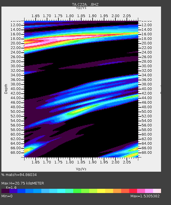
| Estimated Moho Depth: |
20.75 km |
| Estimated Crust Vp/Vs: |
1.60 |
| Assumed Crust Vp: |
6.438 km/s |
| Estimated Crust Vs: |
4.023 km/s |
| Estimated Crust Poisson's Ratio: |
0.18 |
|
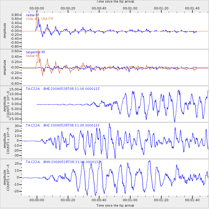
| Radial Match: |
94.86034 % |
| Radial Bump: |
278 |
| Transverse Match: |
89.37343 % |
| Transverse Bump: |
366 |
| SOD ConfigId: |
2648 |
| Insert Time: |
2010-03-07 00:13:09.363 +0000 |
| GWidth: |
2.5 |
| Max Bumps: |
400 |
| Tol: |
0.001 |
|
Signal To Noise
| Channel | StoN | STA | LTA |
| TA:C22A: :BHZ:20090528T08:31:06.000013Z | 17.097296 | 1.5742946E-6 | 9.207858E-8 |
| TA:C22A: :BHN:20090528T08:31:06.000013Z | 2.8295922 | 5.060206E-7 | 1.7883164E-7 |
| TA:C22A: :BHE:20090528T08:31:06.000013Z | 2.4511807 | 4.6631317E-7 | 1.9024023E-7 |
| Arrivals |
| Ps | 2.1 SECOND |
| PpPs | 7.7 SECOND |
| PsPs/PpSs | 9.8 SECOND |


