You are here: Home > Network List > TA - USArray Transportable Network (new EarthScope stations) Stations List
> Station C22A Vida, MT, USA > Earthquake Result Viewer
C22A Vida, MT, USA - Earthquake Result Viewer
| Earthquake location: |
North Of Svalbard |
| Earthquake latitude/longitude: |
80.3/-1.9 |
| Earthquake time(UTC): |
2009/03/06 (065) 10:50:29 GMT |
| Earthquake Depth: |
9.0 km |
| Earthquake Magnitude: |
6.6 MB, 6.5 MS, 6.5 MW, 6.4 MW |
| Earthquake Catalog/Contributor: |
WHDF/NEIC |
|
| Network: |
TA USArray Transportable Network (new EarthScope stations) |
| Station: |
C22A Vida, MT, USA |
| Lat/Lon: |
47.75 N/105.88 W |
| Elevation: |
745 m |
|
| Distance: |
45.6 deg |
| Az: |
293.604 deg |
| Baz: |
13.279 deg |
| Ray Param: |
0.07117029 |
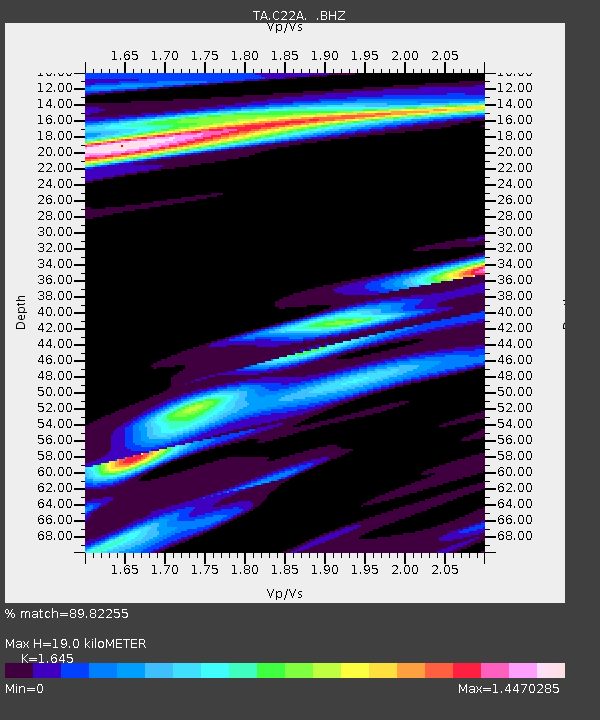
| Estimated Moho Depth: |
19.0 km |
| Estimated Crust Vp/Vs: |
1.64 |
| Assumed Crust Vp: |
6.438 km/s |
| Estimated Crust Vs: |
3.913 km/s |
| Estimated Crust Poisson's Ratio: |
0.21 |
|
| Radial Match: |
89.82255 % |
| Radial Bump: |
337 |
| Transverse Match: |
68.17632 % |
| Transverse Bump: |
400 |
| SOD ConfigId: |
2658 |
| Insert Time: |
2010-03-07 00:13:14.920 +0000 |
| GWidth: |
2.5 |
| Max Bumps: |
400 |
| Tol: |
0.001 |
|
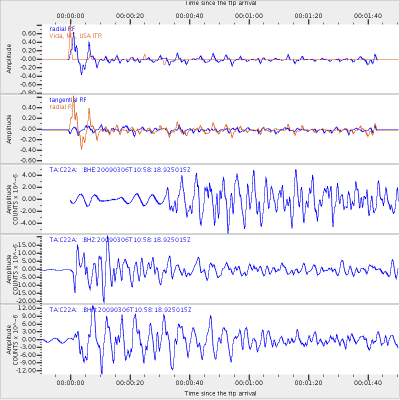
Signal To Noise
| Channel | StoN | STA | LTA |
| TA:C22A: :BHZ:20090306T10:58:18.925015Z | 31.45988 | 7.026543E-6 | 2.233493E-7 |
| TA:C22A: :BHN:20090306T10:58:18.925015Z | 8.679671 | 3.4774087E-6 | 4.0063827E-7 |
| TA:C22A: :BHE:20090306T10:58:18.925015Z | 2.0678186 | 1.0611536E-6 | 5.131754E-7 |
| Arrivals |
| Ps | 2.0 SECOND |
| PpPs | 7.3 SECOND |
| PsPs/PpSs | 9.3 SECOND |


