You are here: Home > Network List > TA - USArray Transportable Network (new EarthScope stations) Stations List
> Station C22A Vida, MT, USA > Earthquake Result Viewer
C22A Vida, MT, USA - Earthquake Result Viewer
| Earthquake location: |
Kuril Islands |
| Earthquake latitude/longitude: |
46.0/151.4 |
| Earthquake time(UTC): |
2009/04/18 (108) 19:17:58 GMT |
| Earthquake Depth: |
35 km |
| Earthquake Magnitude: |
6.3 MB, 6.3 MS, 6.6 MW, 6.4 MW |
| Earthquake Catalog/Contributor: |
WHDF/NEIC |
|
| Network: |
TA USArray Transportable Network (new EarthScope stations) |
| Station: |
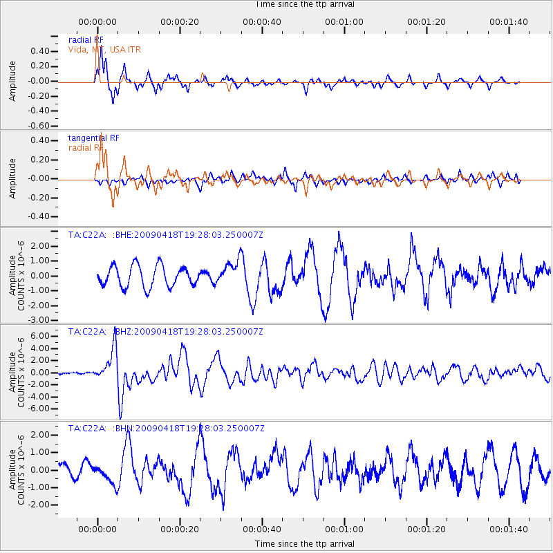
C22A Vida, MT, USA |
| Lat/Lon: |
47.75 N/105.88 W |
| Elevation: |
745 m |
|
| Distance: |
64.8 deg |
| Az: |
46.695 deg |
| Baz: |
311.286 deg |
| Ray Param: |
0.058638077 |
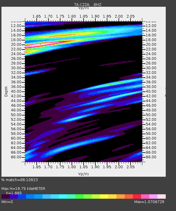
| Estimated Moho Depth: |
19.75 km |
| Estimated Crust Vp/Vs: |
1.66 |
| Assumed Crust Vp: |
6.438 km/s |
| Estimated Crust Vs: |
3.866 km/s |
| Estimated Crust Poisson's Ratio: |
0.22 |
|
| Radial Match: |
89.10923 % |
| Radial Bump: |
272 |
| Transverse Match: |
66.99419 % |
| Transverse Bump: |
400 |
| SOD ConfigId: |
2658 |
| Insert Time: |
2010-03-07 00:13:17.625 +0000 |
| GWidth: |
2.5 |
| Max Bumps: |
400 |
| Tol: |
0.001 |
|
Signal To Noise
| Channel | StoN | STA | LTA |
| TA:C22A: :BHZ:20090418T19:28:03.250007Z | 17.618492 | 2.8208287E-6 | 1.6010614E-7 |
| TA:C22A: :BHN:20090418T19:28:03.250007Z | 1.7500423 | 5.2211516E-7 | 2.983443E-7 |
| TA:C22A: :BHE:20090418T19:28:03.250007Z | 1.2022115 | 8.3717725E-7 | 6.9636434E-7 |
| Arrivals |
| Ps | 2.1 SECOND |
| PpPs | 7.8 SECOND |
| PsPs/PpSs | 10.0 SECOND |


