You are here: Home > Network List > TA - USArray Transportable Network (new EarthScope stations) Stations List
> Station C22A Vida, MT, USA > Earthquake Result Viewer
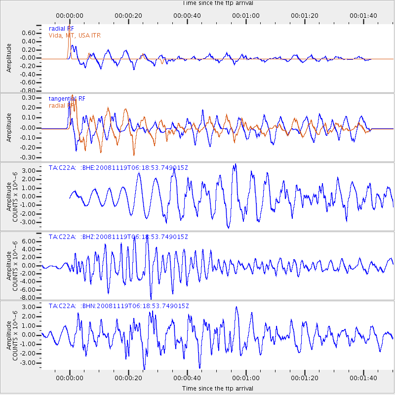
C22A Vida, MT, USA - Earthquake Result Viewer
*The percent match for this event was below the threshold and hence no stack was calculated.
| Earthquake location: |
Panama-Costa Rica Border Region |
| Earthquake latitude/longitude: |
8.3/-83.0 |
| Earthquake time(UTC): |
2008/11/19 (324) 06:11:20 GMT |
| Earthquake Depth: |
32 km |
| Earthquake Magnitude: |
5.9 MB, 5.9 MS, 6.2 MW, 6.1 MW |
| Earthquake Catalog/Contributor: |
WHDF/NEIC |
|
| Network: |
TA USArray Transportable Network (new EarthScope stations) |
| Station: |
C22A Vida, MT, USA |
| Lat/Lon: |
47.75 N/105.88 W |
| Elevation: |
745 m |
|
| Distance: |
43.9 deg |
| Az: |
337.724 deg |
| Baz: |
146.227 deg |
| Ray Param: |
$rayparam |
*The percent match for this event was below the threshold and hence was not used in the summary stack. |
|
| Radial Match: |
69.23367 % |
| Radial Bump: |
400 |
| Transverse Match: |
52.51343 % |
| Transverse Bump: |
400 |
| SOD ConfigId: |
2658 |
| Insert Time: |
2010-03-07 00:13:48.836 +0000 |
| GWidth: |
2.5 |
| Max Bumps: |
400 |
| Tol: |
0.001 |
|
Signal To Noise
| Channel | StoN | STA | LTA |
| TA:C22A: :BHZ:20081119T06:18:53.749015Z | 3.159638 | 1.2113802E-6 | 3.8339212E-7 |
| TA:C22A: :BHN:20081119T06:18:53.749015Z | 2.1663694 | 1.1035522E-6 | 5.094017E-7 |
| TA:C22A: :BHE:20081119T06:18:53.749015Z | 1.7836944 | 1.7682672E-6 | 9.91351E-7 |
| Arrivals |
| Ps | |
| PpPs | |
| PsPs/PpSs | |


