You are here: Home > Network List > TA - USArray Transportable Network (new EarthScope stations) Stations List
> Station C22A Vida, MT, USA > Earthquake Result Viewer
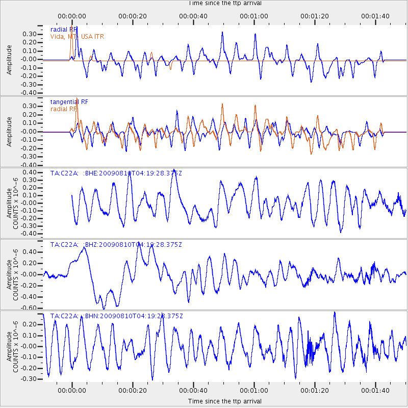
C22A Vida, MT, USA - Earthquake Result Viewer
*The percent match for this event was below the threshold and hence no stack was calculated.
| Earthquake location: |
Santa Cruz Islands |
| Earthquake latitude/longitude: |
-11.6/166.1 |
| Earthquake time(UTC): |
2009/08/10 (222) 04:06:31 GMT |
| Earthquake Depth: |
35 km |
| Earthquake Magnitude: |
5.8 MB, 6.3 MS, 6.6 MW, 6.6 MW |
| Earthquake Catalog/Contributor: |
WHDF/NEIC |
|
| Network: |
TA USArray Transportable Network (new EarthScope stations) |
| Station: |
C22A Vida, MT, USA |
| Lat/Lon: |
47.75 N/105.88 W |
| Elevation: |
745 m |
|
| Distance: |
97.2 deg |
| Az: |
42.829 deg |
| Baz: |
260.727 deg |
| Ray Param: |
$rayparam |
*The percent match for this event was below the threshold and hence was not used in the summary stack. |
|
| Radial Match: |
52.327106 % |
| Radial Bump: |
400 |
| Transverse Match: |
42.57087 % |
| Transverse Bump: |
400 |
| SOD ConfigId: |
2622 |
| Insert Time: |
2010-03-07 00:13:54.742 +0000 |
| GWidth: |
2.5 |
| Max Bumps: |
400 |
| Tol: |
0.001 |
|
Signal To Noise
| Channel | StoN | STA | LTA |
| TA:C22A: :BHZ:20090810T04:19:28.375Z | 5.002053 | 3.5426964E-7 | 7.082485E-8 |
| TA:C22A: :BHN:20090810T04:19:28.375Z | 0.8322457 | 1.5095868E-7 | 1.8138716E-7 |
| TA:C22A: :BHE:20090810T04:19:28.375Z | 1.4997137 | 2.4999628E-7 | 1.6669601E-7 |
| Arrivals |
| Ps | |
| PpPs | |
| PsPs/PpSs | |


