You are here: Home > Network List > TA - USArray Transportable Network (new EarthScope stations) Stations List
> Station C22A Vida, MT, USA > Earthquake Result Viewer
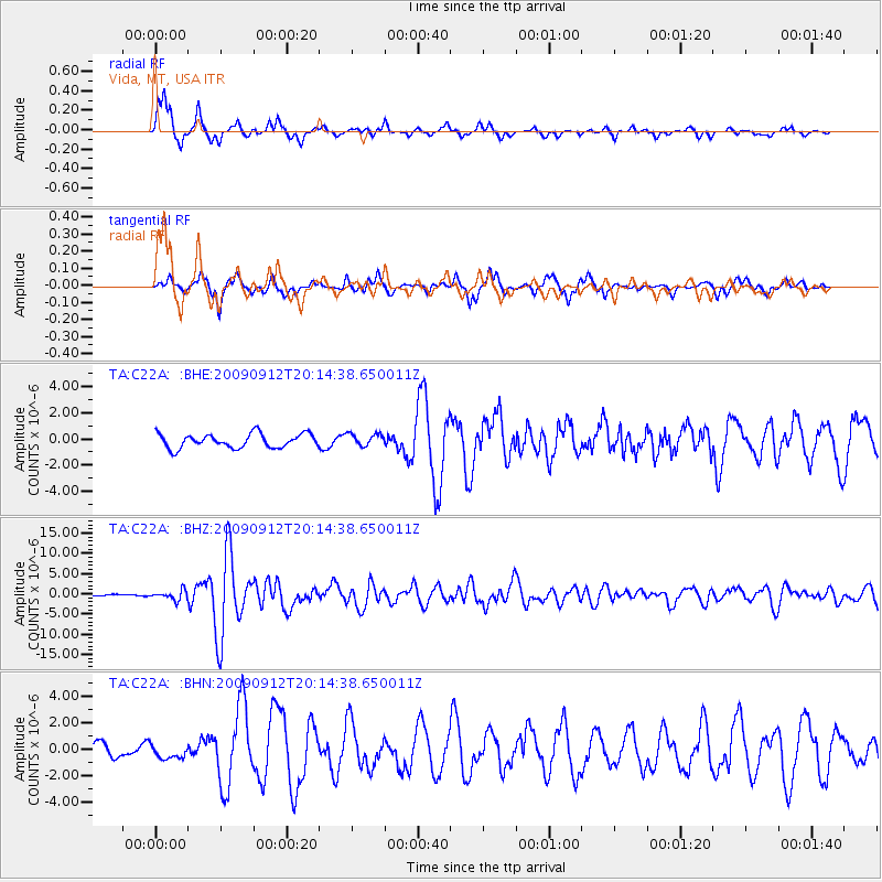
C22A Vida, MT, USA - Earthquake Result Viewer
*The percent match for this event was below the threshold and hence no stack was calculated.
| Earthquake location: |
Near Coast Of Venezuela |
| Earthquake latitude/longitude: |
10.7/-67.9 |
| Earthquake time(UTC): |
2009/09/12 (255) 20:06:24 GMT |
| Earthquake Depth: |
10 km |
| Earthquake Magnitude: |
6.3 MB, 6.4 MS, 6.3 MW, 6.3 MW |
| Earthquake Catalog/Contributor: |
WHDF/NEIC |
|
| Network: |
TA USArray Transportable Network (new EarthScope stations) |
| Station: |
C22A Vida, MT, USA |
| Lat/Lon: |
47.75 N/105.88 W |
| Elevation: |
745 m |
|
| Distance: |
48.8 deg |
| Az: |
326.491 deg |
| Baz: |
126.49 deg |
| Ray Param: |
$rayparam |
*The percent match for this event was below the threshold and hence was not used in the summary stack. |
|
| Radial Match: |
92.60068 % |
| Radial Bump: |
382 |
| Transverse Match: |
85.33666 % |
| Transverse Bump: |
400 |
| SOD ConfigId: |
2622 |
| Insert Time: |
2010-03-07 00:14:01.655 +0000 |
| GWidth: |
2.5 |
| Max Bumps: |
400 |
| Tol: |
0.001 |
|
Signal To Noise
| Channel | StoN | STA | LTA |
| TA:C22A: :BHZ:20090912T20:14:38.650011Z | 7.3968425 | 1.1833547E-6 | 1.5998106E-7 |
| TA:C22A: :BHN:20090912T20:14:38.650011Z | 1.1235744 | 4.732348E-7 | 4.211869E-7 |
| TA:C22A: :BHE:20090912T20:14:38.650011Z | 0.8900504 | 4.7407462E-7 | 5.3263796E-7 |
| Arrivals |
| Ps | |
| PpPs | |
| PsPs/PpSs | |


